 |
| What's New | Links | FAQ | Contact |

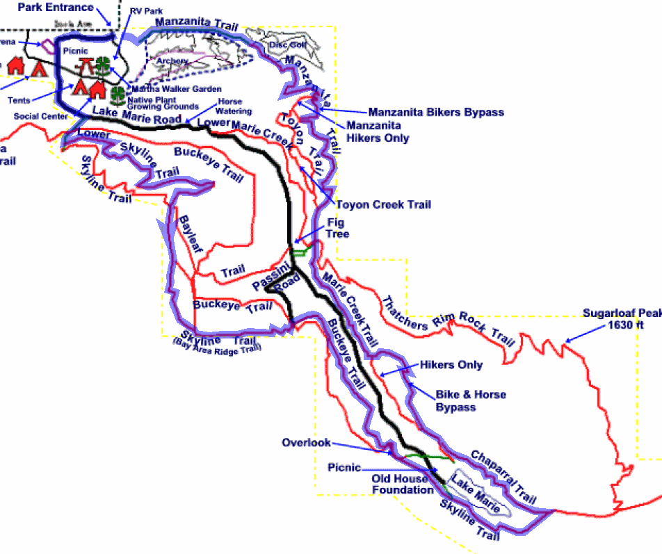
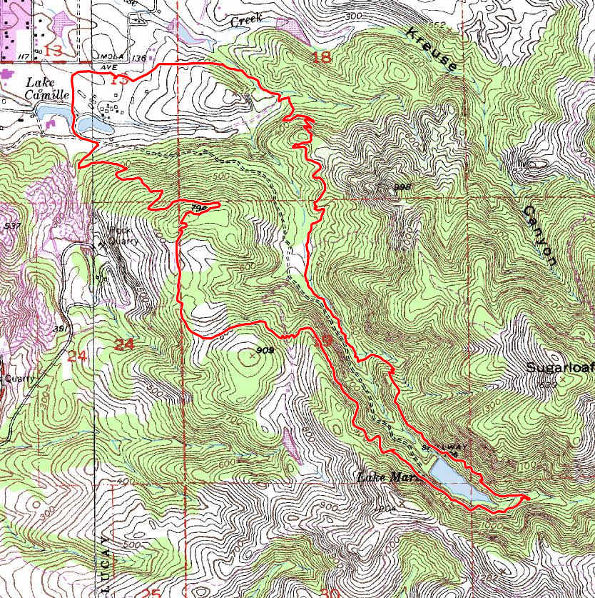
GPS Track Suggested Parking Park Map: Highlighted Original (PDF) Topographic Map Park Website Photos |
Skyline Wilderness (Suggestion 1) 81% SINGLETRACK19% FIRE ROAD 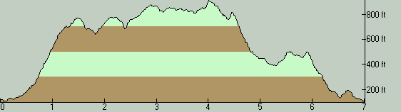
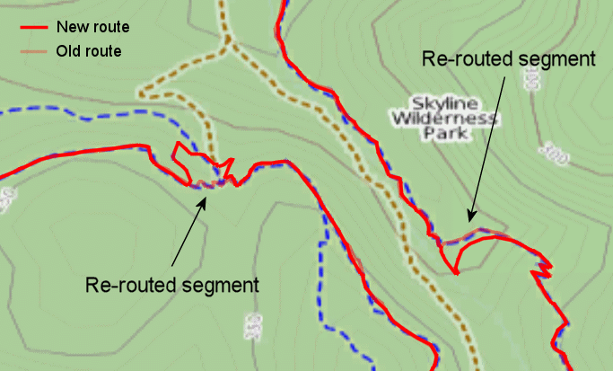
THE PARKI'm sure most local riders would agree that Skyline Wilderness Park is one of the few parks in the North Bay with first-class technical singletrack. The trail network in this park is not exactly huge (some recent texts state its total trail length as 25 miles) but, with a handful of exceptions, all of the trails here (most of which are deliciously technical singletrack) are open to bikes. This is not a ride that can be recommended to beginners, unless what they're interested in is taking a close look at what highly technical trail riding is like and they're okay with having to walk much of the route for the sake of that. Many of the trails are full of seriously narrow and rocky sections, drops, steps, steep and loose stretches, and combinations of these. Other than short stretches here and there, this ride is bound to be a source of nothing but frustration to inexperienced riders. For the same reason, the place might qualify as a hard-core mountain biker heaven, though one with a relatively small selection of trails! And we don't have too many places around the Bay Area for which that can be said. Comparisons with places like Skeggs Point, Annadel, and Soquel Demonstration Forest are inevitable; but even in those places, the technical features of the trails aren't always as incessant and as tightly packed as they are here, in my opinion. Skyline Wilderness Park opens at 8:00 AM. There's no way to enter the park anywhere around its main entrance unless you're willing to scale fences blatantly. However, a reader has tipped me off that, if you're inclined to plan a ride here that will start really early in the morning, you can legally enter the park from Route 221 via the River-to-Ridge Trail. You can also park in the nearby free parking lot of that trail, which is reachable from Streblow Drive. Parking in the park's own lot is subject to a fee. As of this writing, the fee for cars carrying mountain bikes is $6. More than four people and more than two bikes per car are subject to additional charges. I didn't see any self-pay system, but the point is moot anyway, since you can't enter the parking lot before the opening time. Although a free alternative is available, I hope that you can opt to use the paid parking lot as a way of supporting this very mountain-biker-friendly park that is quite unique in the way it is maintained entirely by volunteers. The success of this "experiment" could only spell good news for all of us in terms of better access to other such good trails in the future. Meanwhile, if the River-to-Ridge Trail entrance happens to work better for you but you'd still like to support the park, another way of doing it is to purchase an annual pass. THE RIDEThis ride is my attempt at approximating a typical full loop at Skyline Wilderness, in terms of routing as well as direction. The route is fairly short, which is not that surprising given the size of the trail network. What you can do for a more substantial ride is to either repeat the route multiple times (potentially with variations), or add to it as many side loops as you can. Note that a couple of segments of this ride route feature trails that have been re-routed since I've done this particular ride. The changes aren't radical enough to get you lost, but if you do happen to do the ride while closely following the path of this track on your GPS screen, don't be alarmed when you notice a minor divergence. One part of this route that is most obviously a candidate for alternate trail choice is the segment that traverses Lower Skyline Trail, near the beginning. I had picked that as the trail on which to do the initial climb with the hope that, being a seemingly tighter singletrack, at least some parts of it would present some special fun even in the uphill direction. I was mostly wrong; Lower Skyline Trail seemed to me to be a trail best used for a descent (and quite an adrenaline-pumping one at that, in some spots). In the uphill direction, you can save yourself some of the pain by following Buckeye Trail all the way from its beginning, which seems to do a more manageable climb. After you make it to Skyline Trail and then to Buckeye Trail to follow it up the canyon along Marie Creek, you keep gaining elevation but at a much more reasonable rate. This part of the ride is a fun but not very technical singletrack. As Buckeye Trail drops you back onto Skyline Trail for the last time as you near Lake Marie, a gentle fire road descent starts. The glide down this beautifully wooded fire road is so gentle that you can't even coast. This lasts for less than a mile and ends when the trail drops you onto a crossing of Marie Creek. Chaparral Trail, which you take immediately after that creek crossing, marks the start of the return portion of your ride. On your way back, what awaits you is the generally more technical half of the ride. There is no shortage of loose, steep, and rocky stretches of Upper Marie Creek Trail, and the higher parts of Manzanita Trail are peppered with rock and log steps. Meanwhile, the part of Marie Creek Trail that coincides almost completely with the creek itself are very playful, frequently rocky, and nearly guaranteed to get you a little wet when there's a lot of water in the creek. There are a handful of points of interest along the ride. There's the chimney and foundation of an old house visible right next to the trail near the southeastern extreme of Skyline Trail. An ancient fig tree (said to be still producing edible fruit) can be found near Lower Marie Creek Trail. And, of course, there are the pretty views presented by Lake Marie, as well as some nice views to Napa Valley and the upper reaches of the Bay opening up from here and there. But, clearly, the main attractions here are the technical features of the trails, and you usually won't have time to pay attention to much else. © Ergin Guney
Comments: blog comments powered by Disqus |