 |
| What's New | Links | FAQ | Contact |

GPS Track Suggested Parking Park Map: Highlighted Original Topographic Map Park Website Photos |
Downieville (Suggestion 1) 75% SINGLETRACK19% FIRE ROAD6% ROAD 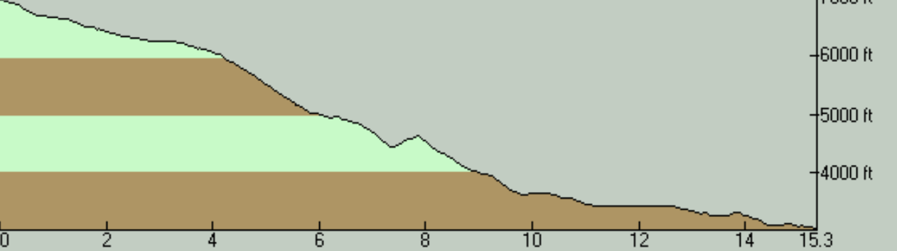
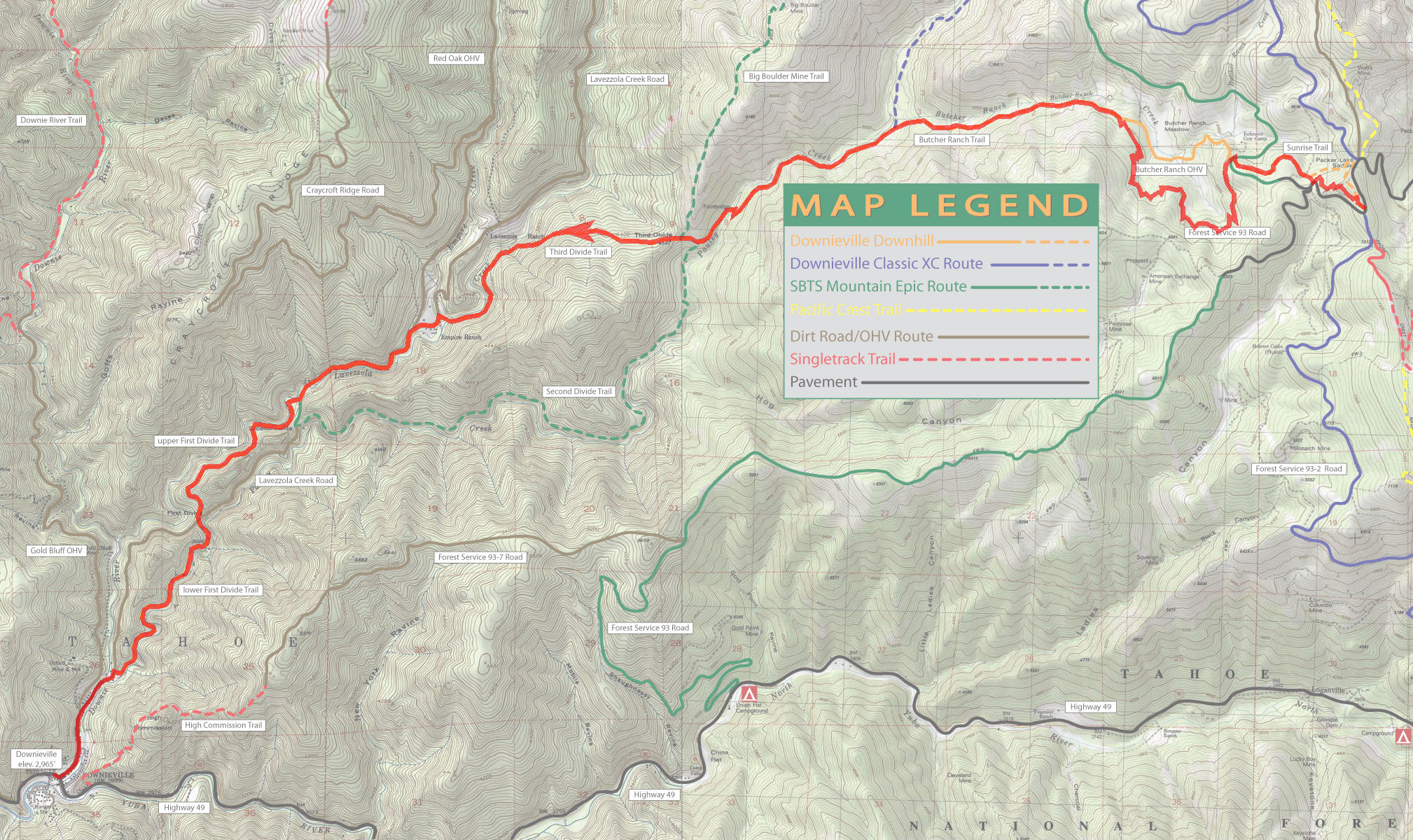
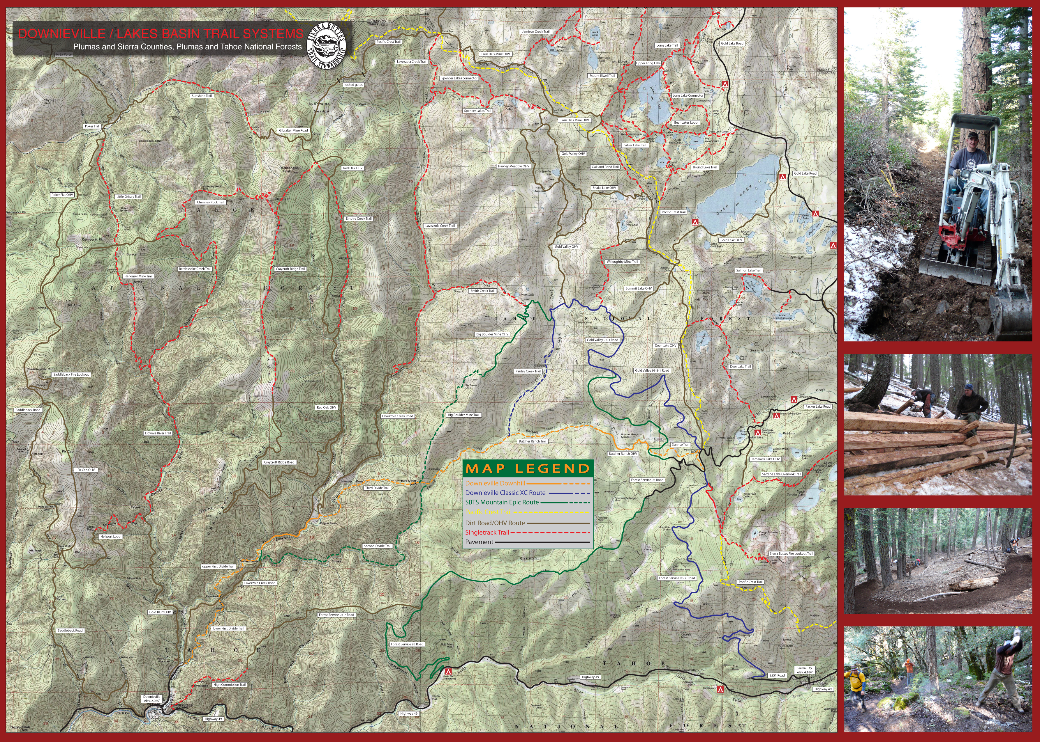
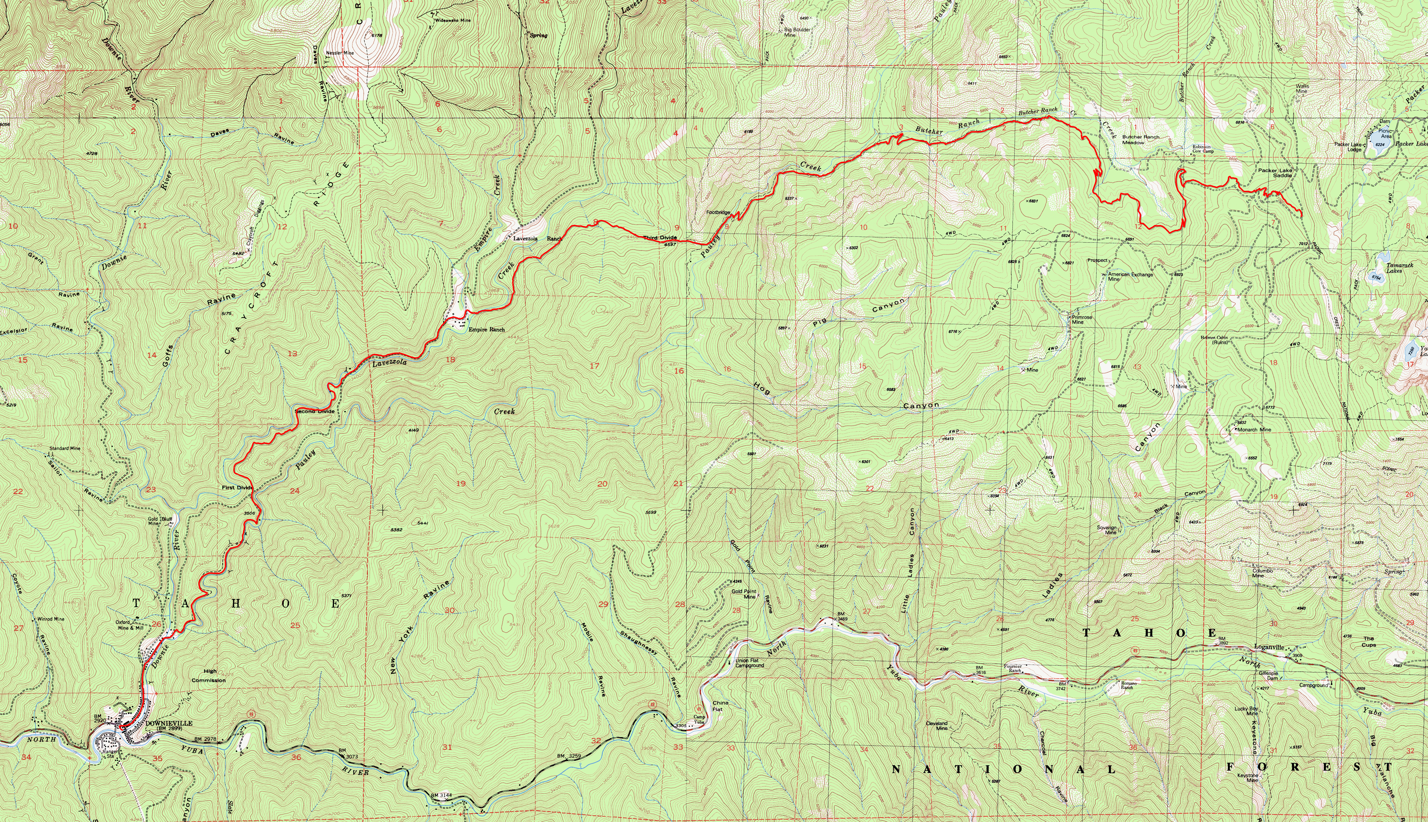
THE LOCATIONDownieville is a tiny gold rush town that today is a little slice of mountain-biking heaven. Arguably, this area's greatest claim to fame is its hosting of the Downieville Classic races. The most popular rides at Downieville are one-way shuttle rides, involving getting on a shuttle from the town center, being driven to a trailhead, and doing a ride that ends right back at the town center after thousands of feet of descent and usually (though not always) with very little extended climbing in the process. The most famous of these is the Downieville Downhill, which, at the time of this writing, continues to follow a close variant of the route shown on this page, and which also happened to be the course of one of the Downieville Classic races and, it's probably safe to say, the ride that has put Downieville on the map. (The exact route of Downieville Downhill is what I used to represent on this page as well, which you can still find here. The current version of the ride is different from this only to benefit from the newer and more fun singletrack portion at the upper end of Butcher Ranch Trail rather than its older, fire-road routing paralleling that stretch.) That race is billed as the longest and toughest downhill mountain bike race in the country. The course descends through a net elevation loss of 3900 feet over 15 miles, with less than 600 feet of total climb in the process. (Other than a half-mile climb gaining 250 feet right at the end of Butcher Ranch Trail, the total climb figure only adds up to this due to the cumulative effect of the minor ups and downs during the naturally undulating flow of the trail along the nearly flat sections.) A great majority of the shuttled mountain bike rides done in the Downieville area start from "Packer Saddle", and that includes the ride shown on this particular page. This trailhead is about a 35-minute drive away from the town center by shuttle van. There are two outfits that I know of in Downieville that operate shuttles there regularly: Downieville Outfitters The rates of the shuttle rides are (roughly, if not precisely) the same between these two outfits as of this writing and they both follow a regular schedule of shuttle departure times, with fewer runs scheduled from Monday to Thursday, and more runs from Friday to Sunday. In addition, if you are part of a group of (I believe) four riders or more, both of these companies are willing to do a shuttle run purely for your group at any time you want, as well as taking you to trailheads other than Packer Saddle if you so desire, according to what I was told. (If you do plan to do that, I'd highly recommend that you double check this with them first, though.) Do keep in mind that these shuttle companies take advance reservations for their shuttle runs and that runs on popular dates could fill up early. Also keep in mind that a lot of the details that I've listed in this paragraph can vary over the years and may have changed considerably since I've written these. Since this area has snow cover throughout the winter, the season that's suitable for mountain biking is limited. Roughly speaking, you can expect the trails to be cleared enough from snow to be ridable some time in early summer, and be buried again at some point in the fall. You can check the trail conditions via the website of either of the two shuttle operators I've mentioned above. In addition to the option of staying overnight in or near Downieville in order to ride here, if you'll be coming from an area not too far away, such as from the Bay Area, it is entirely possible to arrange to do a ride here as part of a day trip as well. The best finish times for this particular route in the Downieville Downhill race are under one hour. Meanwhile, modest riders like me are bound to spend something close to three hours, if not more, to make it through—at least on your first ride, due to the extra sightseeing that would be involved. This would still leave time for a post-ride meal, the shuttle ride, and some overhead, if your one-way drive time to Downieville isn't more than, say, four hours. However, staying overnight would also make it easier to do more than one ride within the same day, which is fairly commonly done by advanced riders. My personal impression around the time I finished this ride was that an immediate repetition of the same ride on the same day (let alone an alternate route, which is bound to be tougher, since this route is the easiest possible one here) would not have been enticing to me at all. The ride left me completely sated for biking for the day. A few words about trail use safety are in order here. These are trails where world-class bikers ride. Most such advanced riders are inclined to ride fast. Moreover, many of these trails are also legal for motocross riders. So, while you ride here, make sure you keep the notion in the back of your mind at all times that another rider could be fast approaching behind you at any moment and, if you ever find yourself stopped on the trail for whatever reason, make sure you step away and stay away from the trail for your own safety as well as for that of others. Meanwhile, if you're one of the said advanced riders who is able to do this ride at double-digit average speeds, make sure you keep your speed to reasonable levels and don't overdo it. Don't forget that these are multi-use trails and also that some riders, though rare, do ride these routes uphill, and avoid riding at speeds higher than would allow you to stop within your line of sight. That one's generally good advice to any rider under any riding condition anyway; you never know when a newly downed tree may be waiting for you just past the edge of your sightline. THE RIDEFirst of all, let there be no mistake: This is an advanced and challenging ride. Don't let the fact that it's "only a downhill" fool you. Inexperienced riders, and those who might feel like bringing along a first-timer riding buddy would quickly find themselves in trouble. Plenty of such Downieville fiasco stories can be found on the Internet. An outright downhill rig is not a requirement to be able to handle the ride (though there is no shortage of places where it would help) and much of the ride is smooth and flowing singletrack. Any experienced rider on a dual-suspension bike would be able handle it comfortably, while hardtail riders doing this ride are not a rarity either, and even riders of rigid bikes on this route aren't unheard of. Still, there are so many highly technical, rocky, and/or loose sections (sometimes for long stretches), not to mention a handful of places that can be outright dangerous, that anyone other than experienced riders who appreciate technical trails are likely to be suffering throughout most of the ride rather than enjoying it. The very first trail in the route is Pack Saddle Loop Trail. This trail splits off Sunrise Trail almost immediately after the trailhead and is a very twisty and flowy singletrack that loses elevation with a lot of economy. It features neatly bermed curves and some other features of flow trails. In fact, some maps still label this trail as "Sunrise Flow Trail", which may have been its initial name. The earlier parts of the trail are under little to no tree cover. Therefore, due to the high elevation, these parts are open to pretty nice vistas of the surrounding ridges and peaks from a few spots as you glide down this trail. Whether you start out on Sunrise Trail or on Pack Saddle Loop Trail at the beginning, you still end up on the lower portion of Sunrise Trail very shortly, as you continue to descend. Sunrise Trail doesn't look or feel very different from Pack Saddle Loop. I remember reading something to the effect that Sunrise Trail uses an easement through private property. So, it would be to the benefit of all of us if riders using this trail would behave responsibly, by avoiding things like skidding, riding outside the trail, taking shortcuts, etc. (though that same principle should apply equally well to every trail anywhere, really). Sunrise Trail eventually meets Butcher Ranch Road. At this junction, you pick up Butcher Ranch Trail by continuing straight across. The first 3.3 miles you cover on Butcher Ranch Trail is a more recently added singletrack segment that bypasses a straighter and wider "Butcher Ranch Road" that's still used for the Downnieville Downhill to bypass this singletrack (at least as of 2019). The singletrack is quite tame and, at the time I ride this, quite smooth by the standards of this ride, but it's still more fun than using the corresponding dirt road segment of Butcher Ranch Road. That singletrack segment ends when you arrive at a spot where the trail crosses shallow and steep-sided ravine in a pronounced "dip". After this point, you're back on the older routing of Butcher Ranch Trail. From here on, things turn a lot more technical. I remember reading that Butcher Ranch is the oldest trail segment on the Downnieville Downhill route and some people believe that the trail is currently overly eroded. It won't take long for this to become evident. The remainder of Butcher Ranch Trail seems like an unending "boulder field" around its middle stretches and has no resemblance to the easier singletrack segment under the same name that you followed up to this point. This must be one of the sections of the route that is the most popular with hard-core downhillers. As for me, I'm not able to stay on my bike for very long along this stretch, so I don't get that much out of it. As you go further on Butcher Ranch Trail (roughly after its junction with Pauley Creek Trail), it turns into a more reasonable forest singletrack, though still a very technical one. Near the end of Butcher Ranch, you cross Butcher Ranch Creek over a bridge and the ride's only real climb begins. When this half-mile uphill section is over, you'll be starting out on the Third Divide Trail. (Second Divide Trail is an alternative to this, which sets out toward the left shortly before the end of the climb. That one makes for a more strenuous option.) Third Divide Trail continues to descend as a singletrack under a canopy of conifer trees. On average, this trail is more flowy than Butcher Ranch. Still, there is no shortage of technical stretches on Third Divide, as well as one or two short but very steep descents (one of which was paved with small porous concrete blocks to control erosion). The fun on Third Divide lasts comparatively shorter (since the trail is only 2.2 miles in length) and you end up finding yourself on a wide dirt road. This is Lavezzola Road. You take this road to the beginning of First Divide Trail. If I understand correctly, it's not an uncommon beginner's mistake to follow this road for all the rest of the way straight into Downieville. Doing that would mean missing out on the final three miles of sweet singletrack left to be enjoyed on this ride. To avoid making that mistake, look for the first bridge the road crosses after you get on Lavezzola Road. First Divide Trail begins immediately past that bridge. First Divide Trail follows a flat profile on average. It will, therefore, have you pedaling more than you've had to up to this point on the ride. Initially it's a verdant, narrow singletrack that follows along a steep hillside a little above the creek bed. Roughly at the midpoint of its length, First Divide crosses to the southern side of Lavezzola Road. Shortly before and for a brief distance after this crossing point, the trail morphs into a fire road. Not long after the junction with Lavezzola Road, it sets off on the right as a singletrack again at a junction that might be easy to miss if you're not paying attention. The slope turns slightly uphill in these final stretches of the ride, and once that uphill stretch is at an end, you find yourself swooping down onto the streets at the outskirts of Downieville after descending steeply along a short chain-link fence. Once the ride is over and you're back in "downtown" Downieville, thoughts may naturally turn to food and drinks. There are a number of options available there, though perhaps not as many as you'd expect. I was pleasantly surprised when I tried the garlicky shrimp tacos at the cute little La Cocina de Oro Taqueria. They have a few outdoor tables available in their back patio overlooking the creek, too. The town is so tiny that you'll have no problem spotting this place or any of the other alternatives if you do any walking for more than two minutes near the town center. © Ergin Guney
Comments: blog comments powered by Disqus |