 |
| What's New | Links | FAQ | Contact |

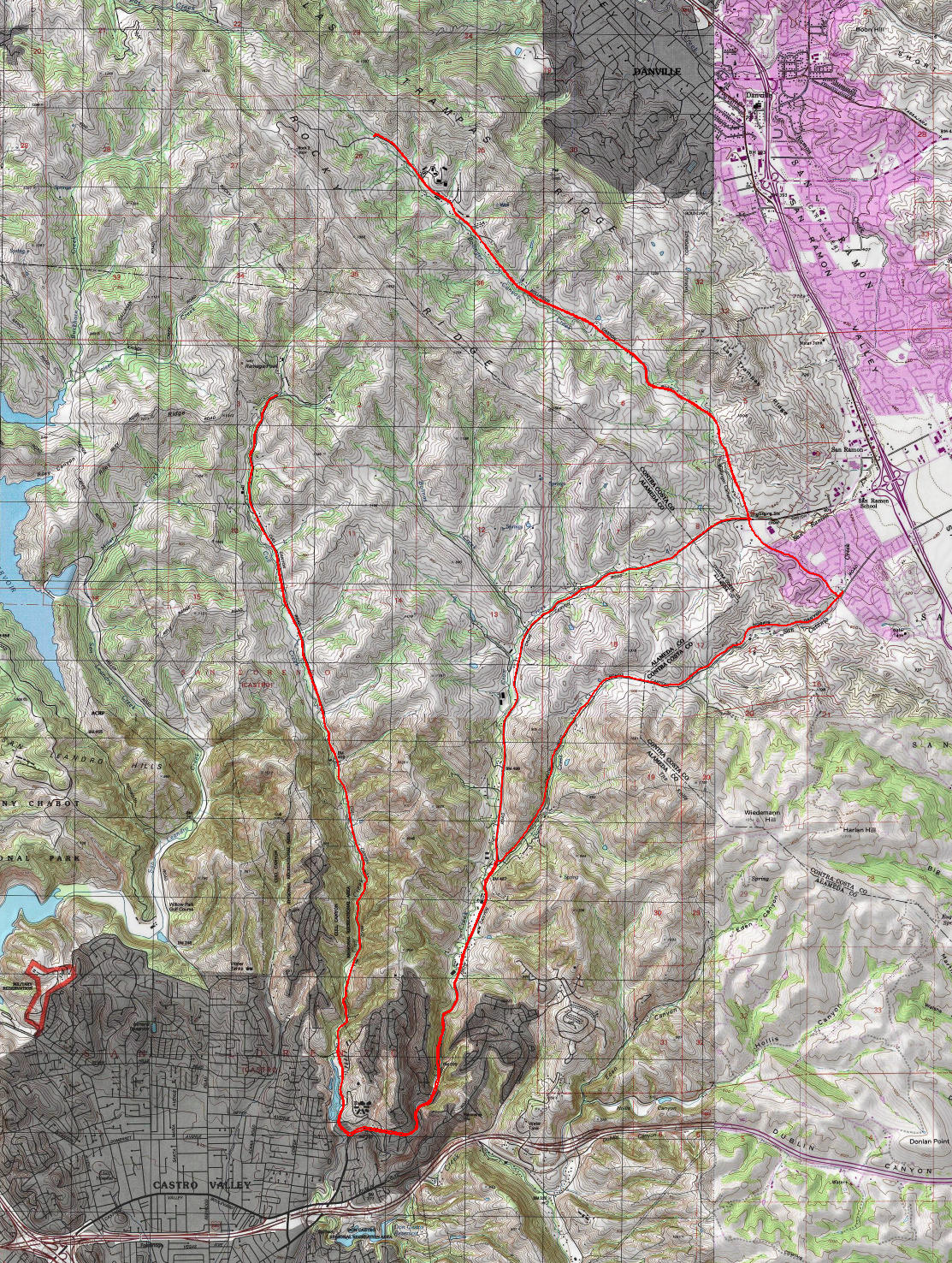
GPS Track Suggested Parking Topographic Map Photos |
East Bay Canyons 100% ROAD 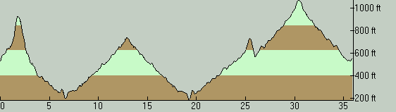
This is a ride that samples some of the little-visited parts of the hilly lands sandwiched between San Ramon Valley and the string of coastal East Bay towns. The sizable patch of land covered by this route in this low-density area features few, if any, bike-legal trails but its secluded beauty can be enjoyed perfectly well by a road ride like this one. The main aim of this route is to explore two dead-end canyon roads: Cull Canyon and Bollinger Canyon. It's simply a nice bonus that Norris Canyon Road is another pretty little valley that can be included in the route when connecting together those two. In fact, you don't set your foot on a single road on this ride that doesn't have the word "canyon" in its name, which explains the title I've seen fit for this ride. Since this route tries to put together two disconnected, dead-end roads into one ride, it's a bit oddly shaped. The fact that I've followed Norris Canyon Road in one direction and not the other when connecting those two roads to each other makes the routing a bit more convoluted by creating a sub-loop. My reason for traversing Norris Canyon Road on the way out was because (1) it came naturally since I had picked a parking spot on that road itself and (2) because I preferred the scenario of doing the larger part of my mileage on that road as a pleasant descent. Norris Canyon Road is a quieter and prettier road than Crow Canyon Road and it has much less traffic. The only reason I didn't use Norris Canyon on the return from Cull Canyon was to keep the overall elevation gain of the ride a little limited, because Norris Canyon reaches a net elevation that is 200 feet higher than Crow Canyon when crossing the hills. Those who don't mind the few extra feet of climbing can make this ride even more enjoyable by using Norris Canyon Road in both directions. If you'll be driving from somewhere else like I did, there are two areas of this route that closely approaches populated areas, providing reasonable parking options. One of these is at the southern extreme of the route in Castro Valley, near the beginning of Cull Canyon Road, possibly on or around Heyer Avenue. The second is in the eastern edge of the route in the outlying neighborhoods of San Ramon and this is the side I opted for because it worked better for the direction from which I'd be arriving. In either case, you'd be looking for street parking in a residential neighborhood. You can also say that the areas on the San Ramon side are more leafy and feel more well to do, but you can decide for yourself whether that makes a difference for you. When you start the ride on Norris Canyon Road, there is climbing from the very start but it's initially a good and gentle warm up as you continue for a bit with bare, grassy slopes on the right and trees on your left. This portion also has very good pavement quality and a paved shoulder of adequate width, though the shoulder's pavement quality is occasionally a bit rougher. Just before you reach the ride's 1.5-mile mark, Norris Canyon Road decides to test your mettle with a climb that is no joke. For a bit over a quarter mile, the road enters a narrow strip of trees nestled in a narrow ravine and climbs nearly 200 feet. There's about a 10th of a mile in that stretch where the average grade appears to exceed 13%. It's bad but it's short enough that most riders in decent shape should have no big problem clenching their teeth and powering through it. The manicured-looking part of Norris Canyon Road ends where the serious part of this climb begins. The curb disappears, the paved shoulder is reduced to an average of no more than a foot in width (which is often interrupted or littered with plant debris), and the evenness of the road surface is dialed back by a notch or two. Norris Canyon Road briefly emerges onto a sunny and grassy saddle point between two valleys at the end of that climb, but doesn't waste too much time there before it begins to descend. When this descent begins, you enter moderate tree cover once again. There is a bit over half a mile at the beginning of this descent where the grade is nearly -9% as an end-to-end average, but the slope is not very consistent even through that stretch. After alternating short stretches of pedaling flatly and coasting gently downhill, Norris Canyon Road hands you off to Crow Canyon Road at a wide intersection. Crow Canyon Road is where you'll find the busiest traffic on this ride. Situated as a shortcut from San Ramon to Hayward and potentially onto the San Mateo Bridge, the popularity of this road should come as no surprise. I'm sure the amount of traffic must fluctuate based on the day of the week and the time of the day but, at the time of my Saturday morning ride, it had what I would consider a moderate amount of traffic. On the positive side, this is a spacious two-lane (or four, over two short segments) with first-rate pavement and paved shoulder space that's consistently two to three feet wide. Your first (shorter) spell on this road will have you nominally descending for a bit under four miles, though you lose only about 200 net feet of elevation over that distance, so it feels little different from a flat ride. And, while the traffic might be on the busy side, the setting of this road is not half bad, actually. Other than the last half mile of the ride before reaching Cull Canyon Road where Crow Canyon becomes a suburban boulevard, most of the road is a nicely twisting road through lush surroundings, and it's especially enjoyable when you're descending it, no matter how gently. Although Cull Canyon Road starts out as a wide suburban avenue like the southernmost stretch of Crow Canyon Road on this ride, it sheds that persona once it leaves the outskirts of Castro Valley in less than three quarters of a mile and becomes a secluded country road. This road constitutes the quietest portion of this ride because it connects to no settlements and there are no major destinations on its upper reaches. This is the kind of cycling road where you don't necessarily need to be too careful about sticking close to the right-hand edge of the road, though it has enough traffic that you can't completely cease to pay attention to vehicles that might be approaching from behind either. The road is not too narrow; it features a solid double yellow line along the middle for its entire length, and its pavement is surprisingly good for a road that seems to service so few people. One curiosity about Cull Canyon that might be worth pointing out is that a nudist resort is situated at its end. Cull Canyon Road is actually a steady climb on your way north. I'm saying "actually" because the overall average grade of this road is under 2% even when you exclude a mile-long flat section near its beginning. Much of the elevation gain on this road seems to take place over short stretches that feature more significant slopes. Still, this is not a road that will feel like work for any regular rider. When you get back on Crow Canyon Road, you naturally return over the same stretch you covered to get there first, which has such a gentle uphill slope that it might feel almost flat, that is with the exception of the very first quarter mile that is an easy to moderate climb with a grade no more than 5%. Once you pass the intersection with Norris Canyon Road again and continue onto the rest of Crow Canyon, the road initially goes through a one-mile segment where the lane count grows to four lanes again. When the road returns to two lanes, it starts to feel like a backroad again a little bit, albeit one with considerable traffic. Meanwhile, the laid-back elevation gain on Crow Canyon Road continues for about 5.5 miles after you exit Cull Canyon. The end-to-end average grade of this segment is less than 2%. The slope is not very even, however, though even the "steep" parts hardly ever reach 5% grade. After that easy segment, Crow Canyon Road puts you through the second stretch on the ride that feels like a real climb, though it's not excessive. The slope still averages only 5% on this stretch, but it's more noticeable because it's unbroken for nearly 0.4 miles. Once you make it over that hump, you find the suburban vistas of San Ramon in front of you as you start a roughly half-mile-long, moderately fast descent. That descent ends at the intersection with Bollinger Canyon Road. At that intersection, you can either turn right to head back to your starting point and cut the ride short, or turn left to ride the second dead-end canyon on the ride. Bollinger Canyon Road is quite similar to Cull Canyon is many respects. The climb on your way up the canyon feels equally as gentle as that on Cull Canyon on average, though the first half mile on Bollinger Canyon Road does feel a little more like work because the grade hovers close to 5% on that stretch and possibly exceeds it once or twice. Past that half-mile, it's quite breezy most of the time. Bollinger Canyon did feel subjectively a bit more open and spacious to me, though that's mostly on a few specific stretches of it. The one big difference I noticed between Bollinger Canyon and Cull Canyon, however, is that Bollinger Canyon carries significantly more traffic. This is understandable, because this road takes you to the dense center of the trail network of Las Trampas Regional Wilderness, which appears to be very popular with hikers. You actually begin the ride's third and last noticeable climb as Bollinger Canyon Road transforms into the driveway of the main staging area for Las Trampas before it ends, but we're still talking about less than a quarter mile that averages barely over 5.5% grade here. Once you turn back from the parking lot of Las Trampas, it's one long, gentle (though uneven) descent back to the beginning point of the ride. This stretch back to Crow Canyon Road is a lot of fun, as long as you help gravity along with plenty of pedaling, just like the descent back down Cull Canyon was. © Ergin Guney
Comments: blog comments powered by Disqus |