 |
| What's New | Links | FAQ | Contact |

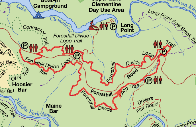
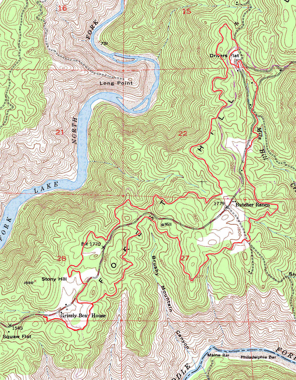
GPS Track Suggested Parking Park Map: Highlighted Original (PDF) Topographic Map Park Website Photos |
Foresthill Divide Loop 83% SINGLETRACK15% FIRE ROAD2% ROAD 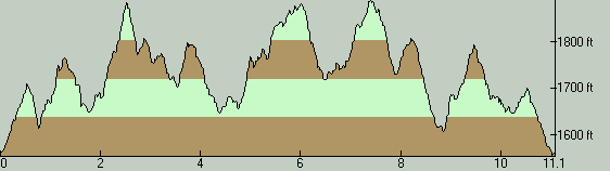
Forest Hill Divide Loop is easily the most well known ride option in the vicinity of Sacramento and Auburn, at least on my mental map of this area. This is hardly suprising, given the fact that these trails were purpose-built for mountain biking (thanks to the efforts of FATRAC), that the ride features one of the highest percentages of singletrack mileage on this website without requiring any grueling climbs, and that it is accompanied by good options for extending the ride with even more mileage of the same high quality. The ride takes place within the Auburn State Recreation Area. The route essentially goes back and forth along a ridgetop, astride the spine of the ridge. The busy Foresthill Road also follows this ridgetop and splits the loop lengthwise into two halves. Seeing that the ride takes place along a ridge that is flanked by two scenic river valleys, you might expect you'll be able to catch a couple of nice views of the rivers along the ride. You'd be mistaken, though. The few views that you get from the core loop are only of the surrounding hilltops. You'll need to pedal off the main loop onto one or two spurs in order to reach vista points that afford any river views. The ride begins from the roadside parking area at a trailhead on Foresthill Road. Despite being "just the side of the road", parking in this space is subject to a day-use fee. The fee was $10 per vehicle the last time I did this ride. You'll need to self-pay by filling an envelope and depositing it, so it would be a good idea to make sure you have exact change and a pen handy. This parking area has space for only about 15 cars, and I got the impression that it's one that might fill up very quickly. If you can't find space here, there are two other trailheads right on the route of this ride where parking is available: the Ruck-a-Chucky trailhead, and an unnamed one where the loop crosses Foresthill Road near the northern end of the ride route. Those two parking options are subject to the same fee, too, but they at least provide some additional capacity. For riders looking for free options, other than the possibility if biking from outside of the Auburn SRA boundaries, one possibility to which I can point is a nearby roadside clearing I noticed on Foresthill Road where parking didn't seem to be prohibited. However, I don't ride in this area regularly, so I'm not at all sure of the formal status of that gravel clearing. The singletrack on Foresthill Divide Loop is mainly pretty smooth, though there are still enough technical trail features to make this into a moderately technical ride and keep experienced riders entertained. There are only a handful of rock gardens along the ride and most of these aren't too memorable. What I think must be the single worst one arrives in the second half of the loop as the trail curves around a sizable tree and is made tricky at least as much by the angle of the turn as the number of tree roots and tall rocks jutting sharply out of the ground. Meanwhile, there are probably more spots on the ride where the dirt surface of the trail itself becomes considerably bumpy (possibly due to hard braking) than there are rock gardens; at least that's how it was when I did this ride. When combined with an increase in the steepness of the trail, these are a good source of fun on what would otherwise be an overly tame ramble through the woods. Speaking of woods, it's worth pointing out that the majority of the ride takes place under light to moderately dense tree cover, consisting mainly of a variety of oak species. This might be one of the factors that contributes to the popularity of this loop, because it means that this is a ride option where you can reasonably expect to find some shelter from the heat in an area where summer temperatures commonly reach levels that are not exactly conducive to comfortable mountain biking. It won't be anything close to the breeziness of the coastal ride options in the Bay Area, but at least there's sufficient tree cover to ensure that the surface of the ground doesn't get hot enough to feel like you're pedaling on a griddle. This ride is one of those loops where there is a particular direction that is generally accepted as the preferable way to traverse it, and that direction is counter-clockwise. On the whole, I think I can say that I've found the second half of the loop to be a little more enjoyable than the first. Parts of the first half felt more like climbing (especially a half-mile segment that starts right at the two-mile mark from the beginning of the ride) while more of the second half had a nice flow to it, though you have more of a need to pedal again as you near the end of the ride. The first half of the ride also has more fire-road segments while the second half has virtually none, although the few fire-road segments in the first half aren't anything to complain about in the first place. In the end, though, the physical difficulty of the ride is fairly low. There is no memorable climb on the ride (espeicially if you don't consider that half-mile segment I've already mentioned) and the total elevation gain adds up to a very modest amount. Given the shortness of the route and its relatively low physical challenge, many riders will naturally look for ways of extending this ride. Thankfully, a very good option for that readily presents itself. It's very popular to combine the Foresthill Divide Loop with one iteration of Lake Clementine Loop, which is a seven-mile loop right at the confluence point of North Fork and Middle Fork American River that strings together a few trails like Lake Clementine, Fuel Break, and Confluence. The reason this is a handy option is the existence of a good singletrack connection that will take you there directly from Foresthill Divide Loop, which is Connector Trail. Just over a quarter mile before the route shown on this page crosses Foresthill Road for a second time near the end of the ride, you can turn right onto Connector Trail, take it all the way to Lake Clementine Loop to ride that, and come back the same way. This will add 14 miles to your ride along with about 2200 feet of additional elevation gain. Beyond that, there are other possible variations that are still within the Auburn SRA as well. Study the map and you should find plenty of opportunities to explore. © Ergin Guney
Comments: blog comments powered by Disqus |