 |
| What's New | Links | FAQ | Contact |

GPS Track Suggested Parking Topographic Map Photos |
Lassen National Park 100% ROAD 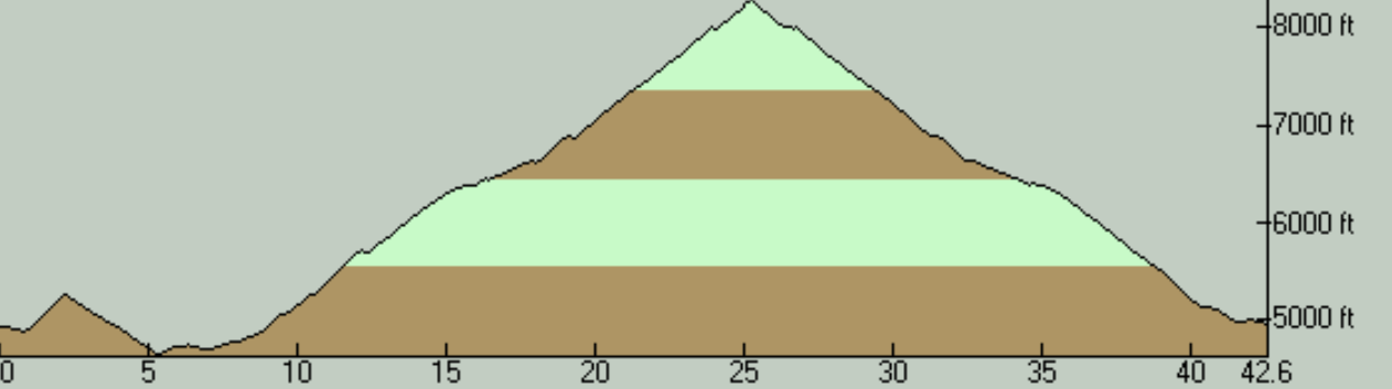
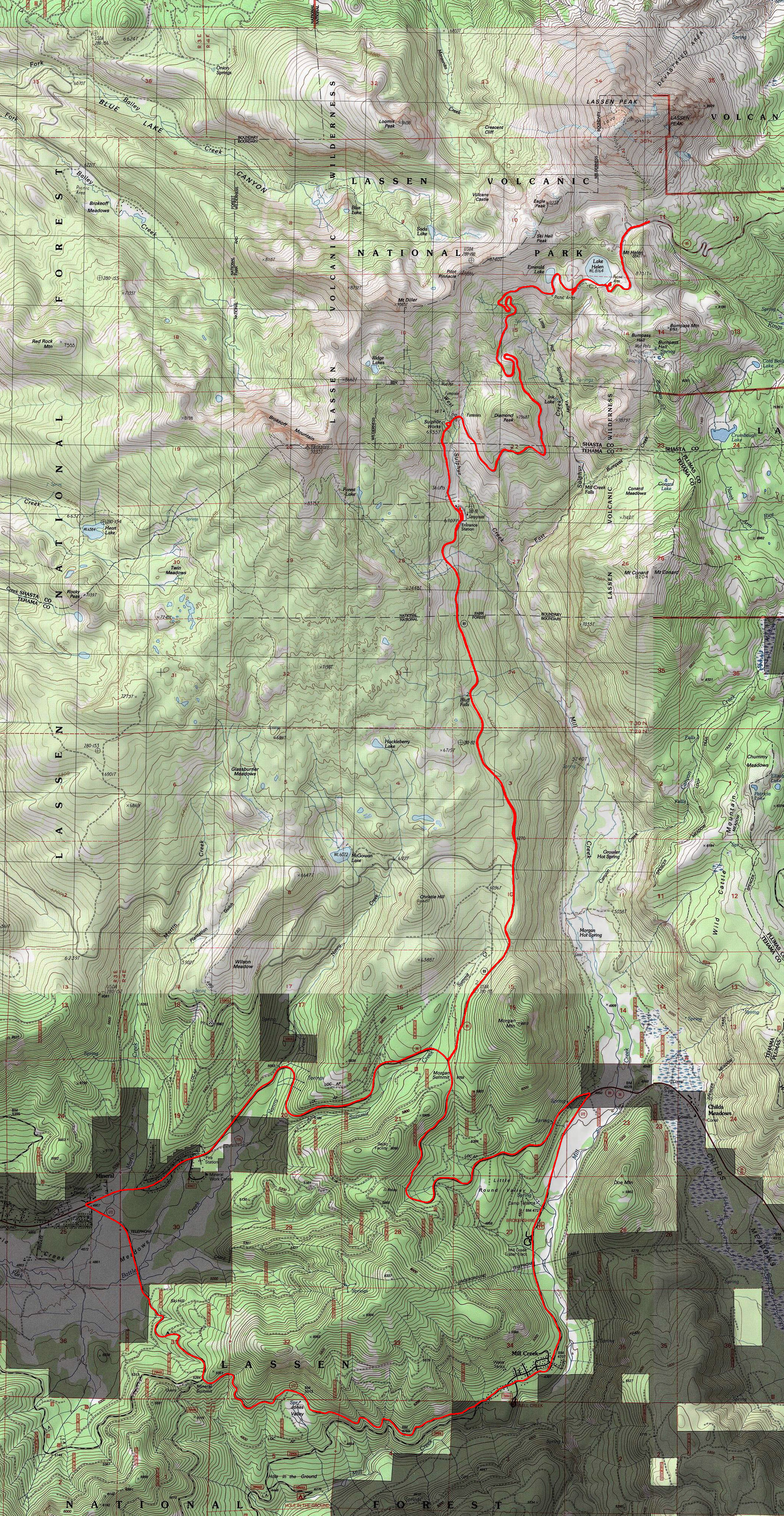
Before I got to try it, Lassen Volcanic National Park had sat quite a while atop my wishlist of road rides to be tried within a weekend driving trip from the Bay Area. I knew the active volcanic geography would make the ride worth the trip along with my expectations of expansive views at the high elevations at which much of the ride takes place. When I tried the ride, it exceeded my expectations. The scenery of the ride is simply gorgeous in my opinion. The sights are not like the ones you would find in Yosemite Valley where your jaw constantly drops wide open, but they are still filled with very picturesque and inviting alpine peaks and slopes covered in pretty vegetation (which is not so dense as to obstruct most views) above a certain elevation. The nice views actually don't open up until you get almost right to the visitor center that comes after the entrance gate. But, after that, they almost never leave you. To appreciate the location of this ride, it would help to know a little bit about the geographic uniqueness of the area. Let me try to provide a capsule summary for those who are not already familiar with it. Mount Lassen is an active volcano whose last eruption happened in 1915, which was the most recent one in the contiguous United States until Mount St. Helens' big show in 1980. Lassen also carries the distinction of being the southernmost one of the string of volcanoes that constitute the Cascade Range and is apparently considered the largest "plug dome volcano" in the world. Perhaps even more interesting to me than those points is the fact that Lassen Peak sits right next door to the shell of a much larger ancient volcano that has blown itself apart long ago. Much of the last few miles of the climb on this ride threads through a roughly circular area with a 3.5-mile diameter that's actually the broken base left behind when this ancient volcano known as Mount Tehama blew its top off in a big way nearly 400,000 years ago. When intact, this prehistoric volcano had a peak that's estimated to have been about 500 feet higher than today's Lassen Peak. Today, the hollowed out carcass of this ancient giant is rimmed by at least four named peaks that form some of the prominent points in the backdrop of this ride, as well as containing within it multiple hydrothermal areas, including two that you get to pedal by: Sulphur Works and Bumpass Hell. The drive here from the Bay Area is not a short one. From San Francisco, the beginning point of the ride is nearly four hours of driving time away. This makes it into a really long day if you try to do the ride as part of a day trip. What I did instead is to stay the night on Friday in Red Bluff and then drive the 45 minutes or so from there to the beginning point the following morning, and drive straight back home as soon as I finished the ride on Saturday. This also allows one to use the cooler early hours of the morning for the lower and warmer parts of the climb, which is an important factor when you consider the fact that the road doesn't even open completely until July, implying that you're almost obligated to do the ride during the time of the summer when the lower elevations in these parts typically experience scorching temperatures. The one natural question that always comes to mind for a ride in the Out-of-Area Rides sections of this website is "is it worth the trip from the Bay Area". My answer to that in the case of this ride is an easy "yes". In fact, even before I was done with the ride, as I was descending to my car, I was making plans in my head regarding when I can bring my other riding buddies for another go-around of this same route. I picked this ride's route from Bill Oetinger's excellent 75 Classic Rides, Northern California book. Anyone who's a regular user of this site will I'm sure have seen multiple ride routes that I attribute to this book and where I praise Bill's informed and inspired route selection and high-quality recommendations. This one seemed to be no exception. I did not regret following his suggested route through Lassen Park. As a national park, Lassen doesn't have too many roads going through it. There's really only one road that cuts through the national park boundaries and that allows access to the higher elevations, and I don't believe bicycles are allowed on trails in the park. Partially as a result of this, any potential loop distances are very long. So, cutting through the entire park and doing it in the form of a loop would have been above my pay grade. Therefore, this reasonable-difficulty ride recommendation from Bill appears to have hit the sweet spot and was able to capture most of the park's lovely highlights in a single, manageable route. The ride route is essentially an out-and-back climb up a mountain, though it does include a loop that it goes around near the starting point. So this is a lollipop-shaped route but you start the ride from the head of the lollipop rather than from its stem. In terms of slope, this is the most gentle mountain climb that I'm aware of. The grade averages around 4.5% end to end. There are steeper segments in a couple of stretches, but those are either barely any steeper (like 5.5%) or are shorter (like a 6% stretch for less than a mile) or both. But this is not to say that this is truly an easy climb. First of all, the climb lasts for 18 miles (depending on where you start counting from), so you do need to have some stamina. But, more importantly for a sea-level dweller like me, the less-than-five-percent grade of the climb felt actually closer to maybe seven percent because of the oxygen level at this elevation. You're already at nearly 5000 feet when you start the ride, and you reach 8500 at the end of the climb. You might not need me to tell you that this route is very seasonal and cannot be ridden in the winter, like any route in high elevations in the mountainous areas of California. However, this one might be one of the surprisingly late-opening roads in this elevation range in that, in most typical years, the road used on this ride cannot be relied on to be open until July and closes up again some time in September. One thing I did change in Bill's ride route is the starting point. His recommendation was to start from the Mill Creek Resort. This is an area without a clear option suitable for parking responsibly for a long ride and it does result in having one last significant climb (in fact the ride's steepest climb on average) at the very end before you return to your car. I decided to start from the tiny town (hamlet?) of Mineral instead, while still following Bill's complete route in the same direction. This meant that what would have arrived as the insult of an additional climb near the end of Bill's route comes instead as your very first climb and works out nicely as a warm-up. You also have a few businesses and a grocery store in Mineral with a generously sized parking lot to use for your ride. I'm not a fan of using parking spaces of a commercial business for a long ride like this, especially if I'm not going to patronize that business before or after the ride. So, this parking suggestion might seem to contradict this personal rule of mine, and technially it does. However, there are a couple of extenuating circumstances in this case, one being the fact that there is ample paved overflow parking available at the spot that I picked that's seemingly much more than the businesses there are ever likely to need. On top of that, it doesn't look at all like this particular spot is under any kind of pressure from cyclists commonly parking there and taking up space that's needed for the customers of the businesses. There is a fee for entering Lassen Volcanic National Park even for people entering the park as pedestrians or on bicycles. That fee is $15 as of 2019, whereas cars need to pay $30 for day use. You pay the fee at a gate that you reach at the 17.5-mile mark of this ride and I do believe they accept both credit cards and cash for payment. The ride begins by taking Route 172 from Mineral toward Mill Creek Resort. This is a very lightly traveled road. Over the nine miles I covered on this road, I believe I encountered no more than two cars. The climb that arrives here has a merciuful grade of a touch under 6% and, as Bill observes in his book, it has the nice perk of being a shorter (about one mile) but steeper climb that is followed by the fun of a mucher longer and winding descent as its reward. At two spots on this road, you also capture very nice meadow views looking untouched and lovely, one right near Mineral and the other right around where you turn onto Route 36. The real climb begins when you turn onto Route 36. The initial segment of that road that you take from this direction will be almost like a connector between Route 172 and the actual main route to the peak approaching from the west. It also happens that this short connector segment of about 2.5 miles feels like the tougher part of the overall climb to the peak. Its grade gets no worse than the first climb of the ride, but that still places it significantly higher than the average of the rest of the slope to the peak. The nicer sights of the park introduce themselves relatively slowly as you start the long, mild, but steady climb on Route 89 toward Lassen Peak along the edge of the Mill Creek valley. As I already mentioned, there isn't a whole lot to look at almost until you enter the national park boundaries actually, though you may catch the glimpse of a nice little waterfall on the way there as well as beginning to glimpse some of the higher peaks in the park through and above the trees fairly early on. The point where you see the park's entrance sign also corresponds pretty closely to the point where you step into the blown-off cone of the ancient Mount Tehama. Things really open up in a dramatic fashion after you climb another mile or so and reach the toll gates and the visitor center, though. This is roughly where the road begins to climb up the edge of the smaller ravine of Sulphur Creek. For me, this happened to be the point after which photo ops and other distractions became almost incessant and slowed my progress considerably. From here to the peak, you go through Sulphur Works where active fumaroles and cartoonishly boiling "mud pots" can be seen from the road, do a gorgeously scenic and curvy climb around Diamond Peak, and round the head of the neighboring gulch, which is Little Hot Springs Valley. Before you reach the turnaround point at the pass adjacent to Lassen Peak, you also pedal by two beautiful alpine lakes and pass by the scenic trailhead for the Bumpass Hell area, the latter of which could constitute a fascinating hike to add to your ride if you have any means of locking your bike somewhere. However, that would probably add up to just under three miles of walking, so plan your timing carefully. And another minor attraction of the ride that's multiplied in these higher elevations are numerous minor streams cutely flowing down the hillsides and often right down to the edge of the road. During my ride in late July, snow on the ground had started showing up shortly before I had made it to the top of Little Hot Springs Valley and was quite widespread by the time I reached the lake area. And the clear, blue waters of the two lakes were almost fascinatingly still partially frozen when I saw them. Some of the best views of the route are to be had from the stretch of Route 89 that climbs up from Lake Helen, which is probably not that surprising since these are the highest elevations of this ride. The turnaround point for the ride's climb comes shortly after this and is at Lassen Summit, right at the highest point of the pass on Route 89 next to Lassen Peak. The elevation of this spot is labeled as 8511 feet. That's good enough for a victory selfie. Bill Oetinger relates that this is the highest paved road of the Cascade Range, which should go a long way toward explaining why it's only open for such a short part of the year. Bill correctly indicates in his book that the turnaround point for this ride doesn't allow any nice views to the east and southeast. You will need to descend a little toward the other side of the pass if you'd like to catch some of those. I can confirm how unappealing the prospect of descending a little further past the highest point of the road at the cost of incurring more climbing on the way back feels at the end of this vigorous climb. However, if you do want to catch the views to the other side of Lassen Peak before you head back, you shouldn't have to go much further than the first set of tight hairpin turns that are reached shortly after you start the descent on the other side, which arrive at something like half a mile after the highest point of the road. I didn't do that on this ride. The main highlight of this ride is clearly the scenery, but the fun and thrilling descent ranks as a close second. The descent is super rewarding and fun at least down to the visitor center area. After that, the rest of the way down becomes less interesting and the views are once again obscured. It still can be fast and thrilling but it's much straighter and the pavement quality is lower and more patchy too. The gentle slope of the climb also means that the descent doesn't always allow you to coast at any significant speed. There are some stretches where you will need to do some pedaling if you are after high speeds. Much of the road to the peak has a speed limit of 35 MPH. However, some spots immediately around high-popularity tourist hot spots have signs announcing a speed limit of 15. In addition to that, those areas also have signs declaring "high-congestion area ahead". Traffic is the worst in the short connecting segment of Route 36 and on its continuation back west to Mineral. I would say the amount of traffic during my ride during that segment of the ride was moderate to heavy. The traffic on the road to the peak is less than that, but not by a whole lot. It may be about half that of Route 36 maybe. However, most people driving on Route 89 to the peak seem to be driving slowly. Part of the reason for this is that they're paying some attention to the nice scenery, especially in the higher elevations of the road. Of course, the flip side of that is that they might be paying less attention to you and whatever else is on the road. So some caution is advisable. The roads on the route don't have any shoulder space, for the most part. There are only very short stretches of shoulder here and there. So, if you want to stay out of traffic's way, you might have to make some effort to ride as close to the righthand boundary line of the road as you can as traffic is passing you by. One exception to this is the return from the junction to Mineral, where you have something around a foot or a foot and a half of paved space outside of the lane line for the most part, which at least gives you a little more confidence when you're trying to track the lane line itself. Also, a word of warning: The gravel run-off after the paved portion of the shoulder, if any, can be very slippery in a lot of places where it's made up of finely granular gravel, especially in cases where the shoulder is sloped. Ask me how I know. The quality of the pavement throughout this ride route is good. I have come across written sources describing this ride as having perfect or excellent pavement. I wouldn't go that far. I would give the pavement a grade of B. This might be because some seasonal damage has caused wear and tear on the surface since the accounts I have read. However, the pavement quality never becomes a pain point or a concern at any point in this ride. During the descent, there's one spot where regular cracks that seem to correspond to the joints of concrete blocks under the asphalt become a little bothersome, but that passes in a moment. One note that may be important to add is a comment I'd like to forward from one of my most useful and reliable ride info sources, Jay's Essential Bike Rides. Jay includes a dire warning about being prepared for mosquitos. He mentions that this was mainly a problem at Summit Lake, which is past the turnaround point of the ride I show on this page. I don't remember noticing a single mosquito during my July ride, but this may be a condition that can change in just a week or two. In addition, Summit Lake is at an elevation of less than 6700 feet, whereas the lakes I passed by are at 8100 and were still almost frozen when I saw them, and most of the slow and scenic part of my ride took place at or above an elevation of 7000 feet. Still, I take this as an important warning to share with anyone who may plan to ride during a warmer time than when I did or may ride further than me. © Ergin Guney
Comments: blog comments powered by Disqus |