 |
| What's New | Links | FAQ | Contact |

GPS Track Suggested Parking Topographic Map Photos |
Lone Tree Road 100% ROAD 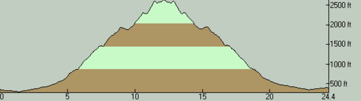
This is an out-and-back mountain climb that starts out from the outskirts of Hollister and heads into the hilly country that's east of there on a no-outlet backroad. In the right season, this is a nicely secluded, though flawed, ride that traverses some very pretty examples of the (arguably) lesser travelled parts of the Bay Area backcountry. Done in the wrong part of the year, however, it could seem like pointless torture under withering heat. The flaws of the ride route consist of the bad pavement quality (more on that below) and the lack of tree cover, the latter of which, while enhancing the scenic aspect of the ride, could result in that hot mess in the notorious heat of this area during much of the summer. If you can time it correctly though (i.e., do it in the mid to late spring), this is an easy ride to recommend to anyone who doesn't mind that their descent may come with some bumpiness. If I remember correctly, I had discovered the existence of Lone Tree Road through its listing on Jay's Essential Bike Rides. Jay gives a very helpful and accurate overview of this ride as well. So, I would heartily recommend his page as an additional source of details and insight about the ride. As far as I can see, there isn't any place that stands out as a naturally good parking spot for this ride. Jay suggests parking at the western end of Lone Tree Road itself. While there is a good amount of roadside clearing next to an agricultural field there, I felt that a parked car there may stick out a little too much like a sore thumb, even though I wouldn't expect that sentiment to be universal. My preferred option was to park a little closer to the edge of Hollister suburbia, in some roadside spaces near the eastern end of Santa Ana Road, about a mile and a half away from the beginning of Lone Tree Road. If you do the ride the way I've done it, the roughly 1.5 miles you'll need to cover on Fairview Road features busy and fast traffic, unfortunately. I don't remember seeing a speed limit sign on that road but, given the speed of the traffic, I wouldn't be surprised if its speed limit is something like 50 MPH. Thankfully, the traffic vanishes immediately when you turn onto Lone Tree Road. I saw only three cars during the 2.5 hours I spent on Lone Tree Road on this ride, and two of those was the same car passing by me twice. Starting with that short "approach" portion of the route to get to Lone Tree Road, the first few miles of the route takes place on flat and straight roads, aligned with the cardinal directions, on the flat part of the Hollister plain. Lone Tree Road does leave surrounding ranches and residences behind and begin to look like open country well before you finish this portion of the route, but it doesn't truly become twisty and begin to feel like a climb until about the four-mile mark of the route. The climb from that point on looks a little "serrated", because its punctuated by short stretches that are flat or even downhill. Many of these are over in a blink, but one half-mile, downhill stretch that arrives at about the nine-mile mark of the ride is quite noticeable and serves as a nice break during the climb. The steeper portions routinely reach 9% grade. A few bad stretches reach 12 or 13 percent. The worst part of the climb arrives near the 11-mile mark, shortly before the turnaround point for the ride, where a half-mile stretch averages 11.5% grade. You also see 14% grade several times within that stretch. The good news about that bad part of the climb is that there's really not a lot more that the ride offers beyond that point, unless you simply must make it all the way to the end of the road. So, riders who find this hardest stretch of the climb to be a little too much wouldn't miss much by turning back without completing it, even though it would mean you'll be shaving off nearly 2.5 more miles off a ride route that's not really that long to begin with. The scenery of Lone Tree Road is simply gorgeous. This is especially so during the few months when the grass is green, as my photos for this ride attest. Even during the straw-colored conditions of the rest of the year, however, the ride's setting will be picturesque. Once Lone Tree Road leaves the flat bottom of Hollister Valley behind, there's not a single flat spot. Meanwhile, the terrain isn't steep enough to hem you in and there's rarely any tree cover to obstruct your view either. As a result of this, virtually all of the time you spend on Lone Tree Road will be accompanied by wide-open views of the surrounding ridges and nearby peaks, and even some views all the way back to Hollister from a couple of spots. In addition, this area seems to feature a lot more pointy and rugged peaks than what I consider average for the Diablo Range. This means that your ride's backdrop often looks a little more dramatic than the typical South Bay ride. The first of these noticeably pointy peaks is Coyote Peak, to which you're introduced virtually as soon as you turn onto Lone Tree Road. You meet Three Sisters and Santa Ana rising like a pair of sentinels on either side of Dos Picachos Creek shortly after that. A little further up, the jagged line of San Joaquin Peak towers over you as you struggle up one of the ride's steeper stretches. The pavement quality of Lone Tree Road was pretty bad when I did this ride. The road's earliest stretches are actually pretty decent, but that ends just as the twisty parts of the ride begin. For all the rest of the way to the point where you turn around, the road's surface consists mostly of patches and potholes, and even the stretches that are intact feature pretty coarse asphalt. This is not much of an issue at the slow speeds of the climb, naturally. On the descent, however, those who crave a smooth, swoopy, and fast descent will certainly be dissappointed. If I've ever done a "technical" road descent, then this must be it. Hence my relatively high Technical Difficulty rating for this ride, among the road rides listed on this site. On the other hand, slaloming to find your path through broken pavement presents its own kind of interesting challenge. Frankly, the road surface isn't bad enough to have taken away much from my enjoyment of the ride. But, this is still a ride that would be better done with a gravel bike or one with wider-than-usual tires. I don't want to overstate the hazards of the pavement, however. What I call "potholes" are rarely of the kind that would pose a threat if you were to hit one. If you have sturdy wheels, you can roll over most of them without giving them much thought as long as you don't mind the bumpy ride. You may notice a sign at some point on your way up Lone Tree Road announcing it to be a "Private Road" and you do go through a couple of gates along the way that would display a "Road Closed" sign when shut. I'm not sure for what kinds of reasons some portions of the road are ever closed, but it's worth realizing that a private road does not automatically imply a road that's closed to the public. (A lot of times, it merely indicates who maintains the road.) Moreover, a sign right at the turn-around point of the ride stating "End of County Road" clearly indicates the legitimacy of the public use of the road all the way up to that point (in addition to seemingly contradicting the "private road" claim of the earlier sign in the first place). So, those of you who may tend to harbor worries about the legitimacy of the ride route should be reassured by this. There's not a lot more to Lone Tree Road after the furthest point you reach on this ride. At the turn-around point, the rest of Lone Tree Road is blocked off by a locked gate, or at least it was at the time of my ride. Beyond that gate, the road continues as an unpaved road, continuing uphill for two more miles, climbing another 800 vertical feet up to the shoulder of Henrietta Peak with a few switchbacks, where it appears to reach a couple of small radio communication facilities right at the county line separating San Benito County from Merced County. As I've already mentioned, there's hardly any tree cover on this ride to speak of. While that's a good thing for the views, it does mean that you won't have much to protect you from the high temperatures of this region's summers. The road does go through clusters of trees a few times, some quite shady, but none of these last for more than a minute or two, and that's only during the slow climb. If you're anything like me, you might wonder where the cute name of "Lone Tree Road" comes from. Trees are nowhere near being rare enough in this area to make you expect a noticeably isolated tree sitting somewhere in the upper reaches of the road that would have given it its name. The USGS topographic map does show a Lone Tree Creek that the road roughly parallels for about 2.5 miles. More significantly, though, the same map marks the top of a minor hill around the 8-mile mark of the ride route (close to where the spring of Lone Tree Creek would be) simply as "Lone Tree", which you can spot on the topographic map that's downloadable from this page. Looking at the aerial imagery of that spot right now, the hilltop clearly features a healthy cluster of trees. However, now that I peruse Google Street View (somewhere around here, perhaps), I realize that most of that cluster seems to be hidden behind the hilltop, leaving only a single tree visible near the top of that hill as you look up from the nearby stretch of the road. That tree is my best guess as to why that spot and this seasonal stream, as well as the road, are called "Lone Tree". I'm sorry to say that I don't have a photo of my own of that hilltop. © Ergin Guney
Comments: blog comments powered by Disqus |