 |
| What's New | Links | FAQ | Contact |

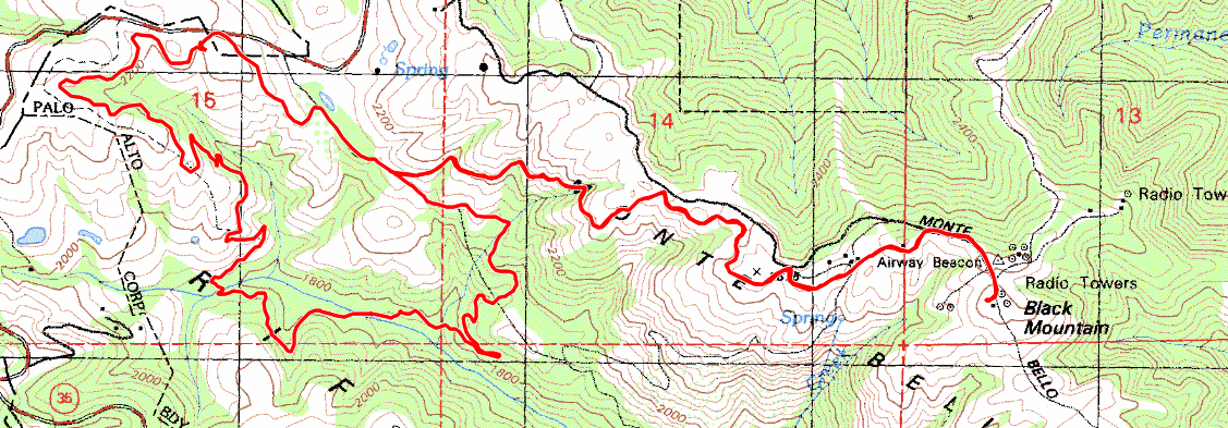
GPS Track Suggested Parking Park Map: Highlighted Original (PDF) Topographic Map Park Website Photos |
Monte Bello Open Space 70% SINGLETRACK30% FIRE ROAD 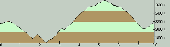
On my "mental map" of biking in this area, the main role of Monte Bello Open Space has more to do with the options it provides as a part of longer loops that start outside the park, with connections to Montebello Road, Stevens Canyon Road, Alpine Road (Coal Creek Open Space), Skyline Ridge Open Space, or Russian Ridge. But, that doesn't change the fact that this park is a decent option in itself for shorter rides within the park's boundaries as well. This particular ride is just such a ride within Monte Bello Open Space itself, one of a handful of rides I habitually do here as a weekday-morning ride before going to work. The gate to the parking lot is unlocked at 8:00 AM. However, I've been told by a park ranger that they don't mind people parking on the wide shoulder along the road next to the Los Trancos Open Space entrance gate (right across the road), as long as you make sure your vehicle doesn't block any signs. So, if you need to plan a start time earlier than 8:00 AM for your ride here, you shouldn't have any trouble parking there. There is almost always space at this roadside area before 8:00 AM, at least on weekday mornings. This ride starts out from the park's parking lot by following White Oak Trail. Its beginning may be hard to notice at first. It's on your right, literally two steps away from the trailhead near the sign board. The trail will have you pedaling gently uphill for a short while near its very beginning, but most of its mileage will take place in the form of a fun, narrow, and playful descent through pretty woodlands. White Oak Trail does have some off-camber spots. Nothing too sketchy, but it does discourage you a little bit from speeding. When I come to think of it, the only other major singletrack trail in this park, Bella Vista Trail, also has quite a few off-camber sections. Perhaps it's something about erosion control. Or speed control. There's also at least one particular hairpin turn on White Oak that's a little over the top in its tightness. But maybe that's a good thing; those of us with superhuman bike control skills need some spots where they can test themselves as well. The last quarter mile of White Oak Trail (after crossing a minor tributary creek over a bridge) has you pedaling uphill at a moderate grade. Your descent resumes when you reach Skid Road Trail and is maintained as you continue onto Stevens Creek Nature Trail. These two trail segments are just two different names for different segments of the same old dirt road that descends toward the main creek bed of Stevens Creek. Today, this trail is in the form of what I'd call a "singletrack on a shelf"—a fire road narrowed by forest debris into a single biking line that's only as wide as a singletrack. It's a moderately fun descent. As soon as you cross the main creek bed (on one of several bridges on this trail), the trail turns into a singletrack again and starts climbing. The climb is initially seriously steep, but it quickly relents a little, as well as becoming wider, and stays that way until the junction with Canyon Trail. Canyon Trail itself is a standard wide fire road. You take this fire road uphill to the start of Bella Vista Trail. This segment on Canyon Trail also includes a couple of short stretches that are seriously steep, one of which reaches a grade of at least 25%. It's almost guaranteed to mean a hike-a-bike for mere mortals, but it's short. The rest of the climb is manageable, though still serious. Bella Vista Trail is another good singletrack trail. It will subject you to a serious but manageable climb, where the average slope barely ever exceeds 10% grade. This trail has very little tree cover and it provides some impressive views as you gain elevation. Near the top of the ridge, after following part of Old Ranch Trail (singletrack) and the uppermost parts of Indian Creek Trail (fire road), you get to the gravel Montebello Road, which quickly leads you to the (fairly flat and nondescript) peak of Black Mountain. On your way down, you take the same route back. (Bella Vista is the most fun way back to the valley floor as well as for climbing up from it.) Once you're back on Canyon Trail, you continue uphill on it. After a short distance, you'll see a signed trail junction with a singletrack trail starting off to your left. You take that trail and stay on it all the way up to the parking lot without taking any turns at the intersections along the way. This is a cute singletrack trail, too, but it's short. Still, it wouldn't be a bad thing for you to try taking it downhill on another variation of your ride here. One piece of information that could save you from a good amount of annoyance is about mosquitos. Most parks in our area have considerable mosquito presence on warm days (with the possible exception of the winter months) and the Stevens Creek watershed is one of the places where this is common. You won't find them in the higher elevations or in the exposed stretches of this ride route but, as you're traversing the tree-covered, lower elevations of this route on a warm day, you can be pretty much assured of being permanently surrounded by a swarm of mosquitos as you ride, unless you're carrying some speed. In my experience, even being covered in insect repellent isn't enough to prevent these annoying creatures from hovering in front of your eyes on such days, though it may help prevent actual bites and may serve to reduce their numbers a little bit. My best advice for avoiding them altogether is to reserve your plan to do this ride for a day when the temperatures will be no higher than 65 degrees. You should also know that White Oak Trail and the trails making up the rest of the portion of this ride that's before Canyon Trail are subject to seasonal closure. So, if you intend to ride here during any part of the wet season, make sure to check the website in advance and find out the current trail conditions. © Ergin Guney
Comments: blog comments powered by Disqus |