 |
| What's New | Links | FAQ | Contact |

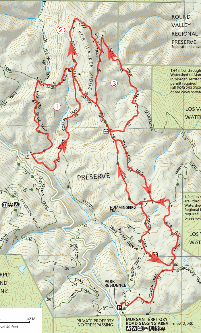
GPS Track Suggested Parking Park Map: Highlighted Original (PDF) Topographic Map Park Website Photos |
Morgan Territory (eastern trails) 100% FIRE ROAD 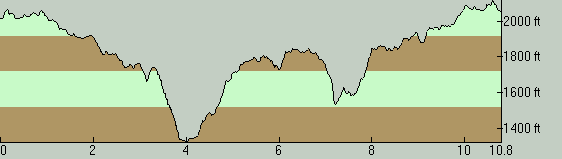
THE PARKThis is an all-fire-road ride deep in the East Bay hills with steep climbs. Morgan Territory Regional Preserve is one of the open space areas that share a border with Mount Diablo State Park, in the hills southeast of Mount Diablo, in an area called the Black Hills. This is a spot that is as remote as it's going to get in the East Bay hills. The trailhead is accessed by traveling several miles on a one-lane road. It's ideal for those who like to commune with nature in isolation. It's pretty much a "wilderness" setting and the nature is beautiful with painting-like oak woodlands on terrain that's always interesting with never a flat spot. THE RIDEThe "eastern half" of Morgan Territory Regional Preserve, where this ride takes place, is the more popular part of this park. Most books and ride guides I've seen, if they list a ride at Morgan Territory at all, almost always show a suggested route in this half of the park. It's not difficult to understand the core reason for that: this part of the park has fewer steep climbs. In fact, those who are interested in a really short jaunt can get away with very little effort if they limit their loop to the middle one of the three sub-loops visible near the northern end of the route you see on this page. The ride starts from the park's own spacious parking lot, whose well signed entrance is one of the few reference points that are relatively easy to find along the remote and deserted Morgan Territory Road. Parking here is free of charge. The location of the park may be out of the way, but the few times I've been at this parking lot, it appeared to be fairly heavily used. So, if you happen to show up here on a particularly busy day and fail to find any available spot, parking might be an issue, since Morgan Territory Road is too narrow to present any roadside parking possibilities. Your best bet for a "plan B" in terms of parking might be to try the trailhead I point out for the other Morgan Territory ride listed on this site, even if it means you'll be starting your ride with the climb up Stone Corral Trail rather than how it's shown here. Having mentioned that this is the comparatively easy part of this park, I'll have to add a caveat for those who might not be familiar with typical East Bay rides: this ride does include a number of tough climbs. This is not a ride that many riders will think of as "easy". It's only because the western half of the park is that much more brutal that this portion of the park can be considered relatively easy. Let's make that clear. The trails along in this park are not only fire roads, but most of them are extra wide and extra smooth fire roads. These must be the "freeways" of the fire road world. It's not hard to imagine that they're kept this way for the ease of access of firefighting crews, but that doesn't make them any more fun for mountain bikers. In the dry conditions under which I did this particular ride, things were fine. But, my experience was quite different when I had done a ride in the western half of this park, on very similar terrain and fire roads, under damp and foggy conditions. Please refer to the text of that ride for a caveat. The parts of this route closer to the parking lot feature gentler slopes and most of the steep climbs are clustered around the northern end of the route. Those who are interested in an easier ride can simply do a shorter version that doesn't reach too far toward that end of this route. Of course, if you keep the ride length too short, it becomes questionable whether coming all the way out here for a ride makes sense in the first place (unless you happen to live nearby). At the very least, the short trip taken through Valley Oak Trail could be left out in order to limit the amount of steep climbing involved, because that segment seems to consist of nothing more than a super-steep descent and a correspondingly punishing climb back up. Similarly, the side loop down Highland Ridge Trail will require that you work your way up another tough climb over Stone Corral Trail to get back up, though at least that sub-loop allows you to enjoy possibly the most scenic descent on this route. Speaking of scenery, most of the long views on this ride are found closer to the northwestern portion of the route, and reach as far as the Sierra Nevada range. So, that might serve as additional incentive to brave some of those steeper slopes. The tree cover on the ride typically consists of scattered patches of oaks. This does make the landscape prettier and allows more opportunities to take in nice views, but during the height of summer, it will also mean that you will find little relief from the heat. If you like this ride but want more of the same, your most immediate options will consist of an extension into the western half of the park. That part of the park connects to the trail network of Mount Diablo, which can take you all the way to Walnut Creek, effectively giving you inexhaustible extension options. Meanwhile, its easier to connect to Round Valley and to the Los Vaqueros Watershed from the eastern half of the park. Two things are worth keeping in mind, though: entering the Los Vaqueros Watershed trails (which I've never tried myself) requires a permit according to the Morgan Territory trail map (though I see no mention of this myself at the Los Vaqueros website), and descending to Round Valley involves almost a 1500-foot elevation loss, meaning you'll have to add that much to your overall elevation gain on the way back in order to return to your starting point, so it's not recommended to those who are skittish about the climbs on these steep fire roads. © Ergin Guney
Comments: blog comments powered by Disqus |