 |
| What's New | Links | FAQ | Contact |

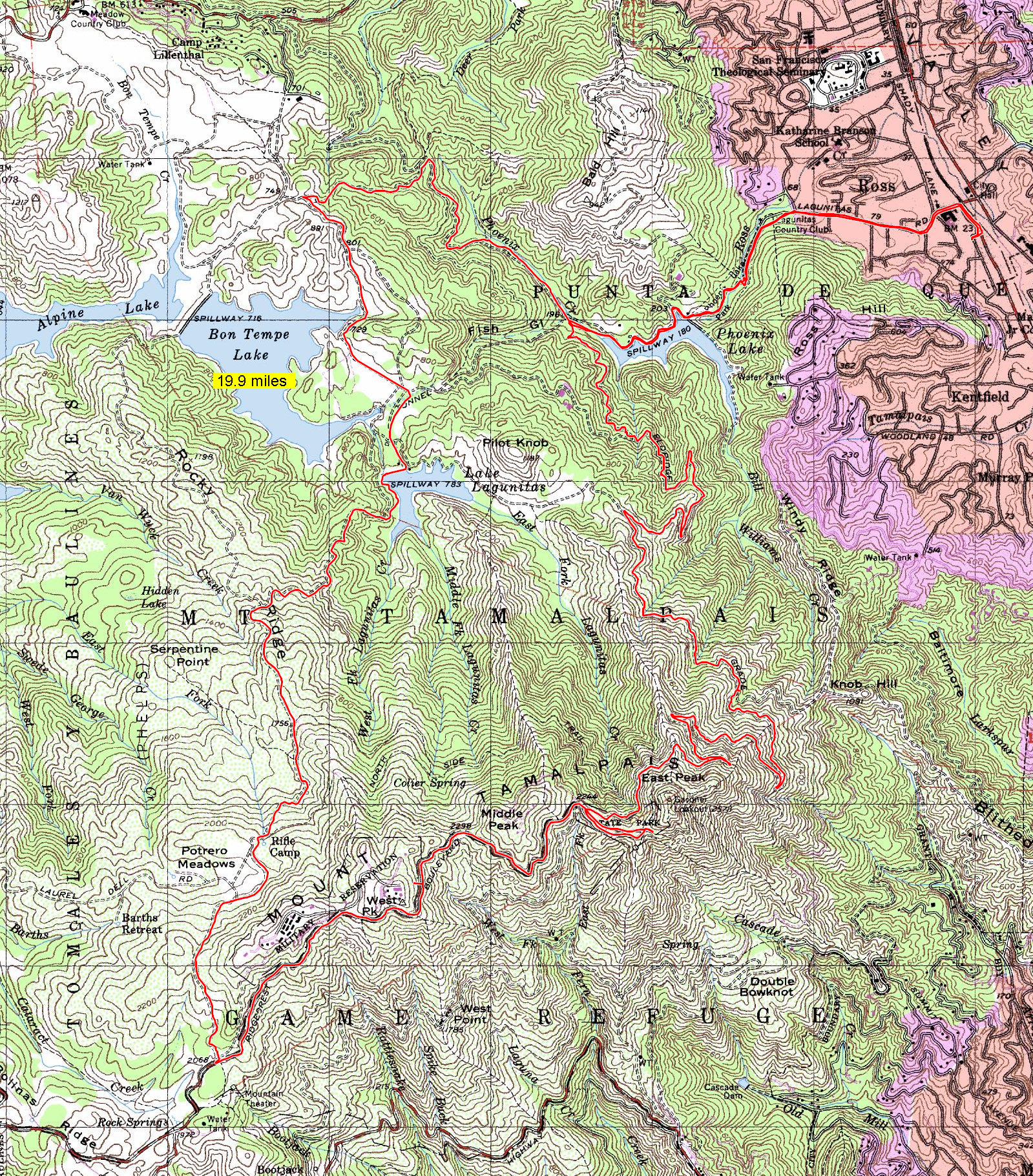
GPS Track Suggested Parking Park Map: Highlighted Original (PDF) Topographic Map Park Website Photos |
Mount Tam (Eldridge Grade and Lagunitas - Rock Spring Road) 65% FIRE ROAD2% PAVED33% ROAD 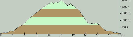
This long trail ride allows you to have half a day of fun on the northern slopes of Mount Tam, including the exploration of a fair bit of the lakes area of Marin and an always pleasing stop to take in the views from East Peak. Two thirds of the ride's mileage takes place on fire roads and the rest is split mainly across four substantial road segments, which are open to traffic. There's zero singletrack to be had on this ride, but there is a fair bit of chunk to be enjoyed, though that's only if you're a fan of "enjoying" chunk in the uphill direction. I don't have an official parking spot to which I can point for this ride. You'll have to find street parking in or around Ross. So, make sure the parking you find is legal and doesn't inconvenience anyone. Another option would be to park at Lake Lagunitas and begin and end your ride there instead. You'll have to pay an entrance fee on the order of $8 to do that, though annual parking passes are also available if you plan to ride in this area a lot. The ride starts out from the town of Ross with the route's first road segment. A short and flat spin through suburban stretches brings you to the entrance of the small but densely wooded Natalie Coffin Greene Park where you hit the trails. You pick up Phoenix Lake Road here, which is the fire road that will take you to Eldridge Grade. There's about a quarter mile of moderate climbing on Phoenix Lake Road before you reach its namesake lake, but that doesn't represent the beginning of the ride's long climb. The long climb begins only when you get to Eldridge Grade. After briefly skirting around Phoenix Lake, you arrive at the junction where the ride's long loop portion begins as you get onto Eldridge Grade. You will stay on this trail for over 6.5 miles and get almost all the way to the peak in the process. The earlier parts of Eldridge Grade start out like any ordinary fire road in a forest: closed in by vegetation and fairly smooth. As you get higher, you start catching increasingly wider views. When you reach the junction with Indian Fire Road (around the 5.5-mile mark of the ride), you begin to ride on the rockier parts of the trail and this continues all the way to the peak. Naturally, this makes the climb a little more challenging. The grade is actually very steady all the way to the top (around 7% on average). If anything, it actually slackens a little bit right before the peak (to about 5%). But, it's so rocky in some stretches near the top that the climb will definitely make itself felt. When Eldgridge Grade ends where it hands you back off to pavement on Ridgecrest Boulevard, you can and should continue on with the last quarter mile remaining up to the visitor area at East Peak before continuing on with the rest of the loop. What might not be immediately obvious at this point is that bikes are allowed to use a second paved path that heads to the peak from this spot but is closed to traffic. This option is to the right of the main driveway as you face uphill. I recommend this path for this short stretch, since it allows you to avoid traffic for a few more seconds. Once you reach East Peak, you might want do a quick stroll on Verna Dunshee Trail before you head back down (not represented on the GPS track downloadable from this page). This is a hiking-only trail, so you'll have to leave your bike behind, which means it would be a good idea to bring a bike lock with you on this ride. It's a half-mile loop circling the peak and providing views like an observation deck all along the way. But, even if you forgo that short hike, the least you should do at the peak is to catch the views at the scenic spot that's just past the restrooms, and visit the Gravity Car Barn to check out old photos of the peak and of the railroad that used to climb up here, and take a peak at the small Visitor Center (if it's open) while you're at it. My photo set linked from this page doesn't do justice to the views one can catch from East Peak, because it was shot on a day with considerable haze and fog. Check out the photos of this ride to get a better idea. Finally, one more useful thing you'll find at the peak is a reliable source of drinking water. Once you're ready to leave the peak, you set out on pavement again. This part involves some additional climbing (350 feet), unfortunately, which can feel quite unwelcome after climbing Eldridge Grade all the way to the peak. On the positive side, there are one or two very scenic spots on this road after you leave that complete that short climb when views of the ocean open up as you twist your way down this mountain road. Your return to trails will arrive at a junction that's easy to miss unless you're well prepared with the knowledge of what to look for. Your clearest clue that you're about to arrive at this junction is a metal gate that can be used for blocking this portion of Ridgecrest Boulevard. Examining my photos near the junction may also help. Even after you turn off the road onto your next fire road here, which is Lagunitas - Rock Spring Road, you start with a short climbing stretch (only an additional 200 feet) before your climbing on this ride ends for the most part. Unfortunately, this last bit of climbing includes some of the ride's steepest stretches. Although the worst part lasts not much more than a quarter mile, it will be the first (and last) time on this ride where you meet grades of 20% and above. Once you overcome that last painful hurdle, your descent on Lagunitas - Rock Spring Road will last for nearly three miles. Most of this mileage takes place under the cover of a conifer forest, though there are a couple of stretches where some views open up, including a sighting of Bon Tempe Lake. The descent does get pretty steep in some stretches (grades of -15% or steeper are not uncommon), so if there's a bit of a speed demon in you, this will be another part of the ride where you can find some extra fun by letting loose a little bit. But never forget that these are all two-way trails... At the end of that descent, you find Lake Lagunitas. Right after you cross over the dam of this reservoir, you arrive at the parking lot where your ride's next paved section begins. Here, you follow Sky Oaks Road as it passes you by two momentary encounters with Bon Tempe Lake too, before getting you to your last trail segment that starts with Shaver Grade. This road segment also includes the ride's last elevation gain worth mentioning, but it's short and easy (about a quarter mile at seven or eight percent grade). The ride's final trail segment isn't particularly remarkable, though it does take you through one of Marin's trail junctions that's famous enough to have its own popular name (Five Corners) and allows you to enjoy one more mile of mild descent. Finally, as you retrace your path back over the "stem" portion of the ride route on Phoenix Lake Road, you might find it easier to see the historic Phoenix Lake Log Cabin. (It can be missed when riding in the opposite direction.) If you like the concept of this ride but would prefer to keep the mileage a little more limited, you'll actually get an opportunity to cut the ride short at the point where you reach Lake Lagunitas. You can take one of multiple trails (Lakeview Fire Road, Filter Plant Road, or Fish Grade) to connect back to the earlier parts of Eldridge Grade more directly at that spot and simply return from there. © Ergin Guney
Comments: blog comments powered by Disqus |