 |
| What's New | Links | FAQ | Contact |

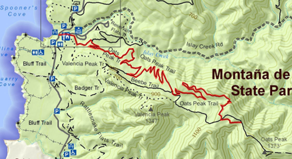
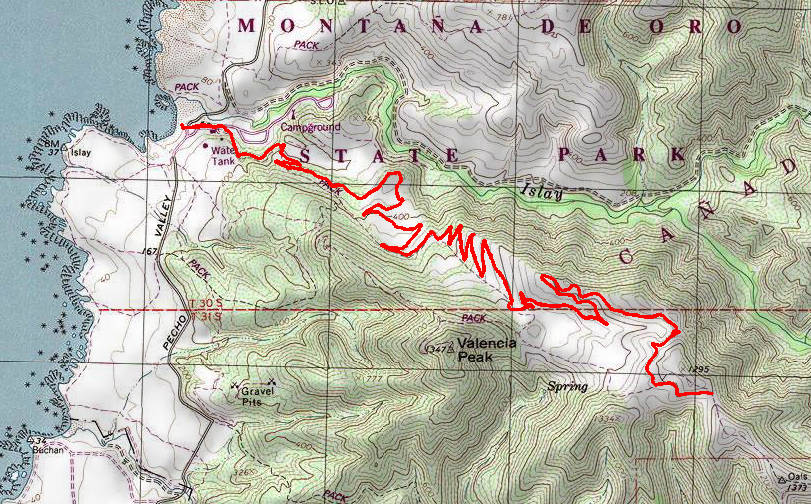
GPS Track Suggested Parking Park Map: Highlighted Original (PDF) Topographic Map Park Website Photos |
Oats Peak Trail 97% SINGLETRACK1% FIRE ROAD2% ROAD 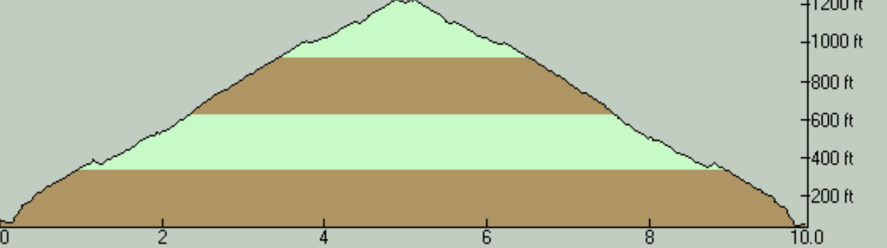
Montana de Oro State Park, I would expect, isn't on the radar of most mountain bikers in the Bay Area, and it originally wasn't on mine either. I first learned about this ride from a short magazine article written about it in 2016 carrying a recommendation for it by Hans Rey, in which he called its area one of his favorites around the Central Coast and described Oats Peak Trail as a "relatively new" flow trail. I'd say any trail that's good enough for Hans Rey is good enough for the rest of us. Hans Rey explains that most people ride this trail as a simple out-and-back starting from the coast, which is how I've done it too. Oats Peak Trail is a singletrack that climbs up a ridge overlooking the ocean. The landscape is treeless and covered mostly in chaparral with views views reaching out to the ocean from most spots. As the "flow trail" mention from Hans Rey implies, the trail is clearly built with mountain bikers in mind. This is evident not only in its gentle grade but also in the fact that it always includes mild twists and small rollers in any stretch that it could otherwise have continued ruler straight, as well as having pumpable humps in some locations and nicely banked hairpin curves, which are especially an advantage when you're descending, obviously. However, this is not an intense flow trail like Endor Trail or Demo Forest's Flow Trail. At most, it's akin to the milder concept of a flow trail like those in Crockett Hills. It's hard to claim that a 10-mile ride is worth a trip from the Bay Area, but the way you should think about this is more as a fun, unbroken, five-mile, singletrack descent with wonderful scenery. As the "flow trail" designation pointed out by Hans Rey implies, this descent can be one long, unbroken joy ride from beginning to end, with the exception of the times you'll need to stop for opposing traffic. Even then, it's hard to recommend a ride that most riders would finish in an hour and a half, when it would take a seven- or eight-hour round trip to get to. But, if there's any other reason that brings you to this vicinity, this ride is a very easy recommendation to make. I should clarify that Oats Peak Trail has been rerouted from beginning to end, seemingly recently. The old incarnation is a much straighter and steeper route up the mountain. Only a couple of short stretches of the new trail overlaps with the old one, though some parts of the old trail are still formally pointed out by current trail signs as alternate routes. However, it needs to be stressed that all the things I describe here and relate Hans Rey as having said apply only to the new routing of the trail. The trails in Montana de Oro State Park are well signed. You would have no problem finding your way on this ride by just following the trail signs, as long as you can remember the name of the one trail that you will be following for the whole route. Parking at the beginning of the ride consists of roadside spaces on the park's driveway, Pecho Valley Road. These parking spaces are free of charge and so is the use of the trail. There was decent availability of parking at the time of my ride, meaning at least two or three spots that I could see were still available as I was finishing my ride around 1:00 PM on a Sunday in May with beautiful weather. For overflow parking, you can try parking in the lot for Spooner's Cove, just a few hundred feet down the road from where I parked. The trail begins right next door to the park's headquarters and visitor center overlooking Spooner's Cove. It starts out almost immediately with a rudely steep climb that might set the expectations of first-timers in a direction that's the complete opposite of the true nature of the rest of the climb to the peak. This 200-yard stretch reaches 20% grade at least a couple of times. Thankfully, this is only to connect you to the main flow of trail that continues much more horizontally along the hillside a little way up from the visitor center. The average grade of the rest of the climb is easy, usually at no more than 5%, and it doesn't get much steeper than that even in temporary spots. The trail makes its way up the ridge through plenty of thoughtfully designed switchbacks. I should clarify, however, that when I call the climb an easy one, I don't mean "easy" in the sense that you can bring your dad along with you for his first time on a bike in 30 years, but "easy" by the standards of a rider who does trail climbs regularly including some tough climbs every once in a while. Oats Peak Trail is a narrow singletrack. The trail surface itself is almost never less than two feet wide or so, and usually more like three, but what really makes it feel narrow is the fact that the vegetation comes right up to the edge of the trail surface on both sides. If not that, then on one side you have a sharp drop-off down a hillside in some cases. This means that it will take some effort in many cases to even find a space to yield to an oncoming rider. The trail surface is most often rocky and usually covered in a good amount of loose pebbles and gravel. It's rarely technical, other than some patches that have mild clusters of rocks that would not even qualify as a rock garden. Most of the rocks on the trail can just be traversed in a straight line without needing any body language at all, especially if you are riding on 29-inch wheels. But the rocks do deserve some attention especially in places where they arrive at curves on your way down. The trail has surprisingly bad visibility. Although there are no trees, the brush surrounding the trail is often high enough to hide an oncoming rider. When you also consider the fact that the trail is hardly ever completely straight, in most cases you can't see what's more than 20 or 30 yards down the trail in front of you. This out-and-back ride turns around at a junction where the nicely designed new routing of Oats Peak Trail terminates. Those who are interested in more mileage can follow the natural (and older) continuation of the trail along the top of the ridgeline toward Oats Peak itself, but it's worth noting that the climbs are much steeper in that portion of the ride if you decide to take it. The character of that extension would be quite incongruous with the rest of this route. The descent on the way back is, naturally, a lot of fun. The mild grade of the trail also means that there are numerous stretches where you can ride without having to use your brakes and the flow is very good. However, considering the looseness of the trail surface, coupled with the fact that the trail is commonly used in both directions (including by hikers) and the bad sightlines, controlling your speed carefully is highly recommended. In fact, there are cow bells available to be borrowed during this ride right at the beginning of the trail. I'm not sure how you're supposed to distinguish the low noise of the cow bell of an oncoming rider from the louder noise of your own cow bell if everyone's equipped with these, but there must be a way that it works. I was using my manually operated bell during the ride. Of course, the views available to you are also considerably better in the return half of the ride, with the ocean in front of you most of the time, although they're not bad at all on the way up either. I'm not sure if this is a common condition or just a seasonal occurrence but, during my ride in early May, fresh poison oak was fairly common on the trail and presented considerable risk. The plants were growing right along the edge of the trail in most cases and often reaching into the trail in a way that could brush up against your leg or arm very easily, especially given the narrowness of the trails. © Ergin Guney
Comments: blog comments powered by Disqus |