 |
| What's New | Links | FAQ | Contact |

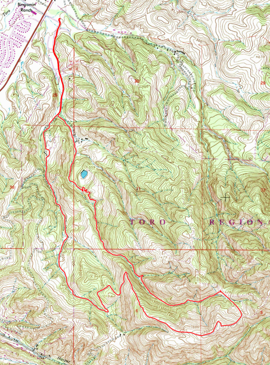
GPS Track Suggested Parking Park Map: Highlighted Original (PDF) Topographic Map Park Website Photos |
Pipeline Trail 34% SINGLETRACK43% FIRE ROAD23% ROAD 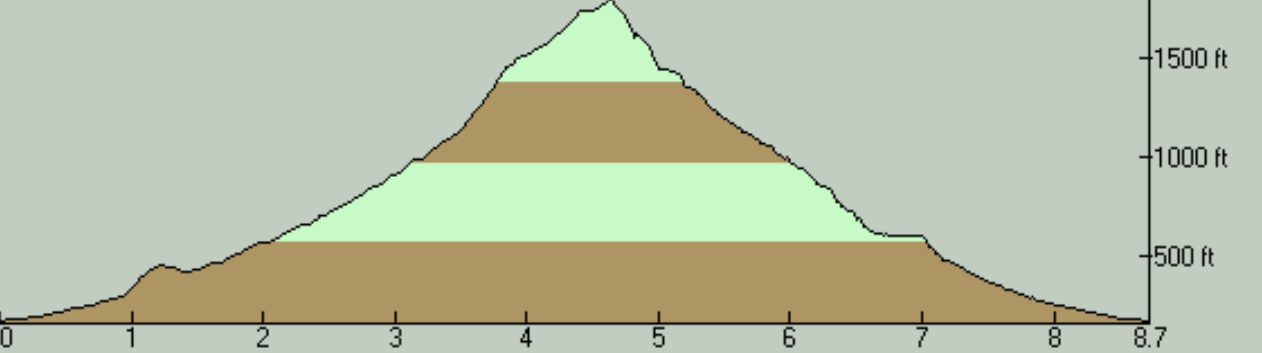
Toro County Park is a large and popular park near Salinas with a lot of trails. There are already a lot of formal trails visible on the park's trail map. But, beyond those, there are a number of additional trails that have their origins in the trail anarchy for which this park has been notorious for quite some time, as far as I understand (for which us mountain bikers are at least partially to blame). In addition to the trail mileage, the park also features several spacious picnic areas in its lowest elevations that are close to the entrance. These are probably the park's most used features and you'll find the biggest crowds in these parts of the park. There are a couple of camping areas a little further in as well. But the highest elevations in the park and the parts that are the farthest from the entrance appear to be used only by mountain bikers and the most determined hikers. Some trails in this park are closed to bikes and all such trails I came across on this particular ride had this clearly indicated on a signpost. This ride is aimed at sampling one of the trails not shown on the park's official map. From a mountain biker's point of view, the clear highlight of the park is Pipeline Trail (or "Pipe Line Trail" according to one trail sign in the park), which is nearly a three-mile singletrack descent, which, despite being built by and for mountain bikers, is one of the sanctioned trails in the "wild west" of the park's trail network. This trail was built (and is mostly maintained, it seems) by a group called Highway 68 Hillbillies, about which I can't find much information online. It was built in 2010 as far as I can gather from this thread on MTBR.com, which appears to be the best online resource about the trail's origin. Not only is Pipeline Trail built from scratch as a bike-specific trail, but it also has the unique distinction of being the only trail I know around the Bay Area that is only for bikes. This is even declared by an explicit sign on the trail, though not at its beginning (its top end). Maybe this makes sense when you consider that the sign is mainly aimed at keeping pedestrians out, who are much more likely to enter the trail from its bottom, which is closer to the busy areas of the park, than from its distant top. The trail also happens to feature a directional restriction in that it can only be ridden downhill. This ride follows the most typical route that would include a descent of Pipeline Trail. It does take you up a punishing climb, but the climb is only of a moderate length and I don't know of any easier way of putting together a ride on which you can sample this trail. There are other loop possibilities that can take you to the top of Pipeline Trail, but they all involve even worse torment on the way up, which must be why they aren't as popular as this route. The worst part of this route's climb begins at the 3.5-mile mark and appears to be referred to by the regulars of this park as "Shit Hill". It does deserve the moniker. The steepest stretch of this climb lasts for about 0.35 miles and averages 17% grade end to end. At it worst spot, my GPS track showed a grade of nearly 25%. Toro Park is fairly rich in parking availability, but the parking lots are subject to a fee. The normal parking fee was $8 at the time of my 2018 ride, but it's apparently bumped up to $10 on holidays, like on the Fourth of July on which I've done this particular ride. I've seen a lot of people parking on the road side just outside the park's gate, along 117th Drive and on a small gravel clearing that's right next to that intersection, clearly to avoid the fee. This park is in need of a good trail map. Of the maps I can find online, including the one shown on the official park brochure on the park's own website, all are out of date to varying degrees, and most have ambiguities and missing details. Virtually all the trail junctions I encountered on this ride have signs. However, the ones that were present at the time of my ride must have been fairly old, judging by their weathered appearance. They seemed to be missing some trails and could be a bit unclear or contradictory to the online trail map. Most notably, Pipeline Trail is not mentioned on any signpost that I could see at its upper end. (It did have multiple signs at the bottom where it ends.) So, if you won't be using a GPS that will show you the way, this route won't be easy to navigate for a first-timer. The ride begins on the paved Ollason Road that passes by most of the picnic areas in the park. The elevation gain begins right from the start, but the slope is very comfortable (at less than %4 grade) at least until the fork of Cougar Ridge Road and Ollason Road. After this, the road does force you into some actual pedaling work over the last quarter mile that you cover on pavement on your way to Ollason Trail but things turn mellow again when you reach the trails. After your tires meet the dirt on Ollason Trail, the first thing the trail does is actually a gentle descent for a quarter of a mile. The climb then picks up slowly. When it's all put together, the first 3.5 miles of the overall ride route features very manageable slopes. The worst of the grade doesn't exceed 13% in this long fire-road climb, with possibly one exception where there's a blip that is close to 18%. This part also takes place mostly under oak trees, although their shade is patchy at best. What changes at the end of those 3.5 miles is the arrival of the ride's steepest climb, as I've already mentioned. Following "Shit Hill", the grade backs off again, but not by a whole lot. You'll be encountering short stretches where grades around 14 and 15 percent are sustained. On the positive side, this is also the part of the ride where the tree cover disappears for the most part. Wide and distant views open up around you the higher you go. There's one last burst of extra-steep climbing in order to reach Ollason Peak itself, though a singletrack (which I took to be a legitimate continuation of the signed Ollason Peak Loop, though it may not be) that approaches it in a little more roundabout way seems like it might make that last push a little easier, and this option is what I followed on this ride. Naturally, the best views of the ride are to be had from Ollason Peak, which is the highest point of this route. The scenery is open in almost every direction from this peak. The descent from Ollason Peak to the beginning of Pipeline is among the steepest descents on this ride. You negotiate a stretch with -33% grade shortly after you set off from the peak, and there's an even worse spot just after you turn left at the first junction on the way down. My GPS recorded a short stretch with -40% grade right around the spot where I believe I took that photo. In fact, that latter spot has a short singletrack bypass that starts off in an S-shaped curve departing toward the right just before it, which I would highly recommend rather than heading straight down. By the time you reach the next junction, which is where Pipeline Trail begins, things are much more sane. It may be worth repeating that there was no sign at this multi-way junction at the time of my ride that pointed out the direction for Pipeline Trail. What I needed to do was follow the sign for Whale Trail and stay on the more well worn path on the next split (which was left). Pipeline Trail is a narrow, often exposed, wild-riding, black-diamond descent on a singletrack that is tucked tightly into the narrow and steeply descending canyon of a dry creek. The trail is frequently off-camber, too. This one is not for the faint of heart. Frankly, it's a little above my pay grade too. The drop to the creek next to the trail is almost never bad enough to spell certain death, though it does look bad enough to make an airlift to the hospital quite likely in most spots. Short and steep ups and downs are repeated on the trail, especially when passing on the uphill side of major trees next to the trail. If you're maintaining an appropriate amount of momentum, the "ups" almost never require pedaling. Some of those steep "downs" were rutted and rooty at the time of my ride, making them more intimidating for me. The slopes of these can be so steep that they can be slippery even to walk. Ask me how I know. In fact, it might be easier to ride many of these than to walk them, if only one has the cojones. Beyond the temporary ups and downs, the trail's overall slope is also fairly steep. A couple of the steepest spots on the trail are even paved with turf blocks. Pipeline Trail starts out with a plunge that gets close to -30% grade at its very beginning. After that, it features and end-to-end average slope of only -10.5% until its short and level stretch that's noticeable on the elevation profile plot. In this nearly 1.5-mile stretch, the grade dips below -15% fairly regularly and exceeds -20% in a handful of spots as well. Following that break where the trail remains level, Pipeline goes a little crazy one last time as it negotaties a tight tangle of downhill curves at grades exceeding -35% in at least one spot. Beyond that, it becomes a reasonable, hillside singletrack as the narrow ravine carved by the stream also begins to flatten out noticeably. There were numerous ramps to catch some air as well as gap jumps on Pipeline Trail at the time of my ride. All but one of these had an obvious and easy bypass available. And even that one exception had a ridable bypass if you gave yourself an extra second to look for it, though it may have been a bit awkward to negotiate it at speed. There are some short wooden bridges without railings to get the trail over some gaps. I'd call them "plank bridges", but they're actually comfortably wide. There's even a short boardwalk to pass around a tree on the outer side at one particular spot (not attempted by me). The trail crosses the dry stream bed multiple times on its way down. These crossings are often easy enough to not be worth a moment's thought, though one or two of them were situated more as "jumps" across the stream instead. The trail does follow an actual pipeline very visibly for a short distance, which must be where it gets its name from. This is effectively a level portion of the trail and I've already mentioned it above. It's very noticeable on the elevation profile plot as a ledge. After a junction with multiple trails featuring trail signs announcing Gibson Trail and Cougar Ridge Trail, the trail quietly continues on relatively level ground for a little more distance before terminating where it drops you back onto the paved Ollason Road. I'm not even sure this last leg of the trail is technically considered part of Pipeline Trail. Some maps show a (seemingly older) trail segment roughly corresponding to this portion that they label as "Lower Lower". Either way, the characteristic parts of Pipeline Trail are long over before you reach these lowest stretches anyway. Since Pipeline Trail follows a narrow creek bed pretty close to its bottom, it's under good oak tree cover for most of its length. The shade is frequently broken, but it's good enough to protect you from the brunt of a hot sun. There's only about a half-mile segment in the second half of the descent where the trail becomes more consistently sunny. Beyond acting as a measure of protection from the heat, the trees on this ride also make the setting more interesting since most of them have moss hanging from them in a picturesque way, much like the majority of trees you'd find at the neighboring Fort Ord. © Ergin Guney
Comments: blog comments powered by Disqus |