 |
| What's New | Links | FAQ | Contact |

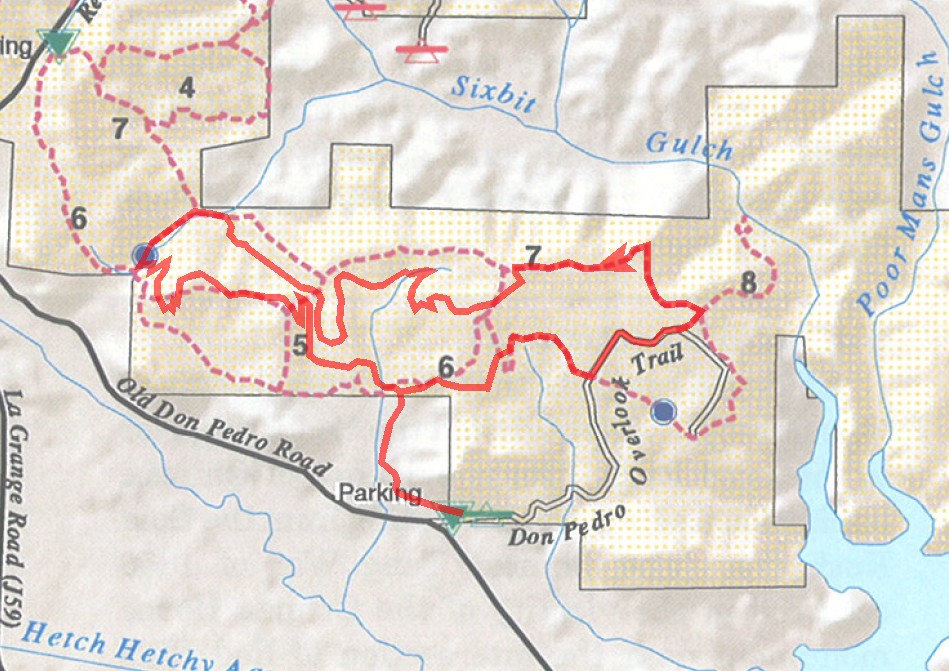
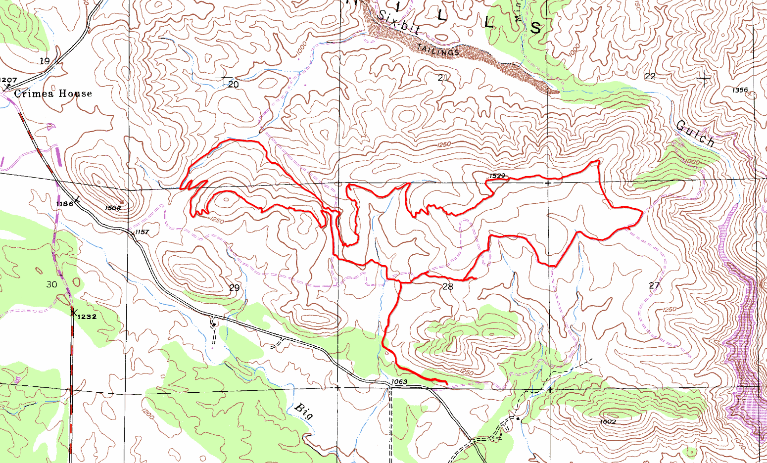
GPS Track Suggested Parking Park Map: Highlighted Original (PDF) Topographic Map Park Website Photos |
Red Hills 92% SINGLETRACK8% FIRE ROAD 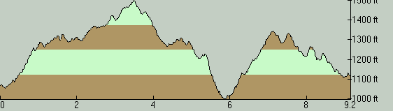
Red Hills has a decent-sized trail network made up mostly of rocky singletrack and with not much net elevation change. If that sounds like an ideal formula for a ride with good flow, that's essentially correct, though only to the extent that you can maintain flow on trails as rocky as some of these can be. The location is not close to any large, or even medium-sized, population centers. It could perhaps be considered a "local ride" for Modesto, Merced, and Stockton, but it would take something like a one-hour drive to get here even from those towns. So, it's a bit out of the way and has a consequently low popularity, as far as I understand. I wouldn't say that Red Hills deserves to be an option near the top of the list for riders looking for a destination within driving range from the Bay Area, but it does hold value as an option for someone looking for a place they haven't tried before. On the other hand, given the fact that it's almost bordered by Route 49 on one side, Red Hills could easily serve as a good mountain biking stop in the course of a camping trip through the Gold Country. The parking lot I used for this ride may be difficult to spot on your first time. It's reached via a gravel driveway that had no sign at the time of my ride and that is long enough that the parking lot is not visible from its beginning. Look for a driveway appearing to continue straight on the left-hand side of the road as Old Don Pedro Road curves gently toward the right at about the 2-mile mark after you turn onto it. It also couldn't hurt to familiarize yourself with what to expect, by looking at this photo of that split. This place shows clear signs of being used more by equestrians than by mountain bikers. Still, that doesn't take too much away from the suitability of these trails for biking. However, you'd be better off expecting more pock marks than hardpack on average. If that's something that might worry you, a little examination of the photos linked on your left could provide you a realistic picture of trail conditions. Those images are from a January ride in a drought year. Much of the singletrack on this particular route is quite twisty. In most cases, it's pretty obvious that this serves no practical purpose but is simply intended for fun. However, there were also portions that I thought were a bit too tightly twisty. This was sometimes at a level that clearly had a seriously adverse impact on the expectation of flow that I've just mentioned. This made me wonder if such tight twists were more enjoyable for equestrian riders, which wouldn't surprise me given the heavy use of these trails by them. Most of the trails at Red Hills make up a tight mesh. As I already mentioned, most of these are singletrack. I have difficulty believing that all of these are consciously planned, sanctioned trails. The downloadable trail map has minimal content and appears clearly to be out of date. So, I have to assume that at least those trails that look well used in the park are legitimate trails, but I have no way of being sure of this. This was my first Red Hills ride, so it's not like I'm intimately familiar with all the route selection possibilities here. However, I did do my homework before trying the ride. The idea for this ride route was to approximate a typical route that traverses most of what appear to be the park's most popular trails, based on the GPS data I could find online. I remember reading recommendations to try trails "on both sides of the road" at Red Hills. The road that refers to is Red Hills Road; not the Old Don Pedro Road that takes you to the trailhead. The ride you see on this page does not follow that advice and stays completely in the "southern" side of the park. However, if you extend your ride in the northwest direction, roughly along the row of hills that make up Red Hills, and cross Red Hills Road, you'll find several more miles of trails on the other side of that road. Red Hills is under the control of the Bureau of Land Management. Its formal designation is as an "Area of Critical Environmental Concern". One or both of these factors may be the reason behind the fact that the trail network here seems to be subject to a very hands-off approach. It probably follows from this that Red Hills has no trails with usage restrictions. Given the abundance of haphazardly placed singletrack connections, there also seems to be a free-for-all attitude here toward blazing new trails, probably also arising from that same reason. That might spell "paradise" to some mountain bikers. On the flip side, however, that could cause trouble for future bike access if things get out of hand and this pattern starts resulting in increased erosion and habitat damage. (Remember that the term "critical environmental concern" is in the formal designation of the place.) That's why I was a bit bothered by the usage pattern I saw in the trails at Red Hills, and it's also why I tried to stick to the most commonly used trails as much as possible, based on wear patterns and on available online GPS data. Trail signs are rare at Red Hills, and many of the turns to be followed on this route are little more than forks in a singletrack through some brush. Quite a few of them are easy to miss unless you roughly know where to look for them. Even though I was following a route on my GPS during this ride, I missed numerous turns myself, which will be obvious when you look closely at the GPS track downloadable from this page. I can see only two reasonable options for someone who will be riding at Red Hills without the company of someone who knows these trails: either bring a mapping GPS that shows a track that you intend to follow and stick to it, or have a willingness to get lost. I know of no good map that would be convenient to follow, and even if there were one, it might not help much due to the lack of trail signs. Some amount of getting lost here might not be bad, because most trails connect to each other pretty quickly. But you need to be careful. The park, while not huge, is not that small either and it's not defined by any instinctively recognizable bounds (such as a sea of surrounding residential neighborhoods, or a tight ring of major roadways). So, you'd better be able to maintain a good sense of bearing if you plan to wing it like that, especially considering how quickly you can find yourself in trouble in this area in the hot conditions of summer. As I've alluded to above, "rocky" is the name of the game at Red Hills. While many of the trails on the ride are consistently rocky—with some stretches even looking like creek beds and extended rock gardens—almost none of them are seriously technical. The trails sometimes seem like they were made for bashing pedals and crank arms, but riders with strong pedaling muscles can simply steamroll over them without slowing down, especially when on a 29er. There are no exposed spots, hardly any super-steep descents, and very few step-ups or step-downs that are really tall. Most of the technical trail features on the ride that looked serious were confined to the descent down a ravine that takes place roughly between the 5.5-mile and 6-mile marks of this particular route. Considering the park is known for its very rocky trails and seeing that most Red Hills rides listed online were on the relatively short side, I took these as signs that this could be the kind of place where a 10-mile ride may feel like an 18-mile ride done on smoother trails. That's the reason I've kept the length of my selected route on the short side. In the end, even with the rocky trails, the route didn't feel like a much longer one after having finished the ride. While I did feel like I could have gone on for another six or eight miles without a problem when I finished the ride, I didn't feel like I hadn't had enough technical singletrack riding for one day either. There is very little climbing on this ride and the slopes are always moderate. However, some climbs can still be tough due to the rocks. Even some climbs with less than 10% grade are rendered challenging by the rocky trail surface in a few cases. Scratches on your arms and legs could be a concern at Red Hills. Long sleeves and long pants would be a wise choice for this ride. A big part of the landscape is dominated by buckbrush, which is the low shrub with the whitish green color that you see in many of the photos linked on the left. This is not a thorny plant, but it's bristling with many short, stiff, and spiky twigs. These probably protect the plant in the same way that thorns would. You will be forced to brush up against this plant often on this ride. The effect is not quite as bad as that of true thorns, but they're still sharp. For non-ride-related activities in the vicinity, the first thing that would immediately spring to mind is points of interest related to the Gold Rush. The semi-ghost town of China Camp is about a 15-minute drive away from the trailhead of this ride. Larger centers that are of interest in terms of Gold Rush history and that are a little farther away but still within range from Red Hills include Angels Camp, Jamestown, and Coulterville. This is not a densely populated area at all, so the more you'd like to see, the more driving will be involved. © Ergin Guney
Comments: blog comments powered by Disqus |