 |
| What's New | Links | FAQ | Contact |

GPS Track Suggested Parking Park Map: Highlighted Original (PDF) Topographic Map Park Website Photos |
Skeggs Point (Suggestion 2) 46% SINGLETRACK34% FIRE ROAD4% PAVED16% ROAD 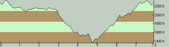
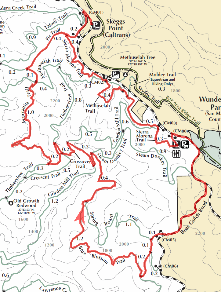
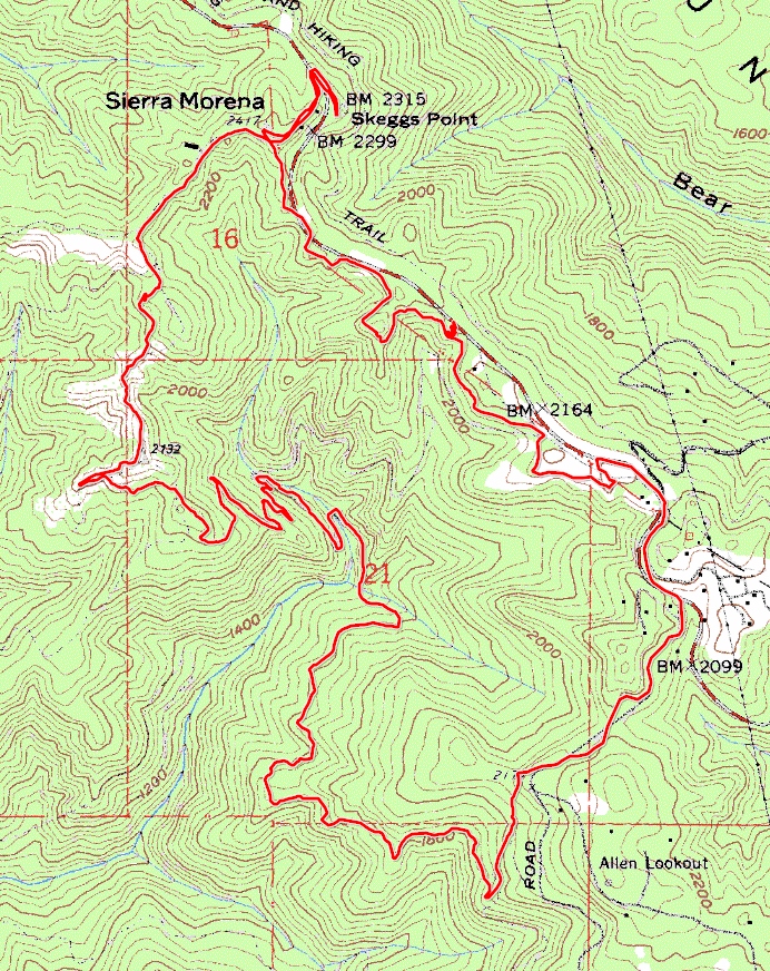
THE PARKSkeggs Point (El Corte de Madera Creek Open Space Preserve) is one of the top candidates for the "best mountain biking location" award in the Bay Area, and might just be my personal number one. The park covers a decent-sized area and features lots of trails, many of them first-class singletrack. These trails also range over a decent spectrum of skill levels. The terrain of the entire park is rugged, hilly, and under forest cover (with the exception of a couple of small patches of chaparral). The park used to be utilized as a motocross playground for some time before the 1990s. (This thread on MTBR is possibly the single best resource on the Internet regarding the history of this land.) Even before (and during) that, it was a logging area. You'll notice this in the names of numerous trails here. Many fire roads in the park are old logging roads. For the same reason, all of the redwood trees you see in the park are second-growth trees (with at least one notable old-growth exception, marked on the park map). One issue with Skeggs Point is that it's accessible to the public only via Skyline Boulevard. The park boundary along Skyline is the highest part of the park and the rest of it extends mostly downhill toward the ocean. For this reason, almost all rides at Skeggs are of the "have your fun first while descending, then pay the price while climbing" kind. Not my favorite... But the quality of the trails in the park more than makes up for it, believe me. It might be worth pointing out that this park has two major parking lots along Skyline Boulevard (in addition to a couple more roadside pockets of parking). The one I'm still in the habit of using is the one at Skeggs Point, which is the one pointed out by the Suggested Parking link on this page. In fact, this lot is not even associated with the park, technically; it's a parking lot of Skyline Boulevard for the Skeggs Point "vista point" (though its "vista" was probably much better before the surrounding vegetation got higher). The common use of this lot for rides here is also the reason El Corte de Madera Creek Open Space is nicknamed "Skeggs Point" among mountain bikers. If you find this parking lot filled up, as it typically will be before midday on most weekends with nice weather, you can try the park's newer parking lot at the gate labeled as "CM00" on the park map, which opened in February 2014. This one is a bit less obvious because it's off the road and entered via a driveway, but you'll see a sign saying "El Corte de Madera Creek Open Space" at the entrance of the driveway, which you can find 0.4 miles north of the intersection with Bear Gulch Road South. The sheer amount of trails here and the lack of long-distance visibility due to the terrain and tree cover mean that it's easy to get lost in this park. Thankfully, virtually all trail intersections are marked, though I'm sure there may be exceptions, and I know of at least one trail junction sign that seems confusing if not downright incorrect. So, if you have a GPS receiver, you might want to use it, at least in cases when your ride here includes trails on which you'll be riding for the first time. Be warned. THE RIDEThis ride starts out by turning onto Sierra Morena trail shortly after entering the park. This is the only trail in the park where you can ride essentially flatly for any significant distance. The trail is a not-too-technical singletrack that mainly follows Skyline Boulevard closely. While it's more or less flat on average, it doesn't mean that there aren't short climbs you'll have to clear here and there. Following this route, you'll be dumped onto Skyline Boulevard for a very short stretch after finishing Sierra Morena trail. To get there, follow Sierra Morena all the way to the parking at lot the CM00 gate and connect to Skyline via the driveway of that parking lot. After turning onto paved Bear Gulch Road, a short but very pretty redwood forest road ride will bring you to the trailhead that leads you to Blue Blossom Trail. This is a very fun singletrack descent. It's usually narrow but not technical enough to be challenging. Its upper reaches are more flowy, and its lowermost sections turn into more of a tight meander through closely spaced trees. After Blue Blossom, you'll traverse the part of the park that has the highest number of trail junctions encountered in a short distance. Doing something like six trail turns in this segment (not to mention some serious singletrack switchback climbing) will get you to Manzanita Trail. Manzanita Trail is another one of the prime singletrack trails of this park. Traversing it in this direction, you'll be doing it uphill. I'm sure most people would say that the "correct" way of riding Manzanita is downhill. I'm of two minds about this. While I agree that riding it downhill is buckets of fun, I also enjoy immensely to climb it. It's one of those climbs that I like because (while being very technical) it's steep enough to be challenging for me without being too steep to handle. Manzanita Trail will throw at you some switchbacks, some sunshine, deeply rutted trail sections, flowy singletrack, rocky sandstone, nearly impossible rocky trail obstacles that might qualify as double black diamond, and portions of trail that look more like a creek bed; though not necessarily in that order. This trail is one of the reasons I keep returning to this park! (Manzanita was somewhat sanitized in 2011. The creek-bed-like sections are still there, as well as some of the exposed sandstone features. But the second most technical spot of this trail has now been reduced to a much less dramatic trail feature.) When you reach the multi-way junction at the end of Manzanita Trail, you'll know that your ride is essentially over. After that point, there's less than a mile of fire-road riding with very little climbing left before you return to the parking lot. One unfailing tradition I have for rides at Skeggs is a post-ride lunch at Alice's Restaurant. If you're from the nearby area, you're probably already more than familiar with this place. If you're not, you shouldn't miss it. It's at the intersection of Skyline Boulevard and Route 84, about four miles further southeast on Skyline Boulevard from the Skeggs Point parking lot. The food is good, and the setting is even better. The place is almost always overflowing with motorcycle riders who stop here on their pleasure rides along Skyline Boulevard. Some cool and fast cars can also be frequently found there for the same reason. © Ergin Guney
Comments: blog comments powered by Disqus |