 |
| What's New | Links | FAQ | Contact |

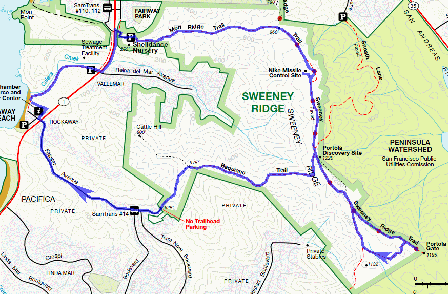
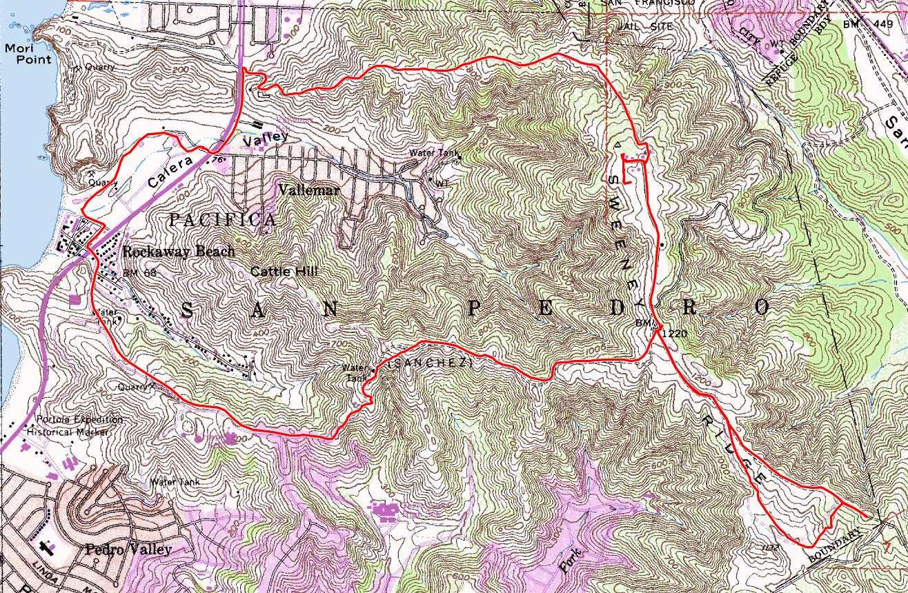
GPS Track Suggested Parking Park Map: Highlighted Original (PDF) Topographic Map Park Website Photos |
Sweeney Ridge 15% SINGLETRACK49% FIRE ROAD13% PAVED23% ROAD 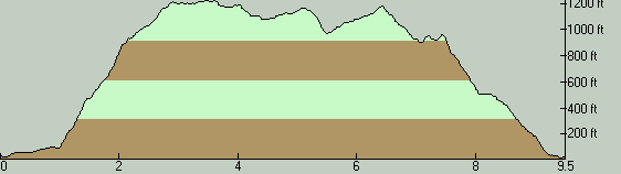
Despite being a short loop that might be enticing only to those who live in the vicinity, this ride does include at least two moderately interesting side attractions. It includes almost 2.5 miles of riding on pavement (with a bit over a quarter mile of this being on Highway 1), a total of about a mile on paved recreational trails, with the rest consisting of fire roads (except two very short stretches that are on singletrack). One thing in which the ride is rich is grand views. Since it takes place on treeless slopes facing the ocean, the views of the sea and of Pacifica are almost incessant. This is accompanied by simultaneous views toward the bay once you're atop Sweeney Ridge. From the suggested parking spot in Rockaway Beach, you start by following a paved trail (marked on the park map simply as "Bike Path") heading north right off the parking lot. This drops you onto Highway 1 in a short while. From here, you follow Highway 1 northward for just over a quarter mile. Note that there's also a continuing paved trail that's on the western side of the road that leads in the same direction, but if you take that trail, you won't be able to turn right where you should, due to the barrier on the road's median. So, make sure you bike up the side of northbound Highway 1 along this short stretch. Your turn off Highway 1 could be easy to miss. It's a driveway (that's initially paved) that also leads to an orchid nursery (Shelldance Orchid Gardens) and you'll be noticing their signs at the junction. The climb along Mori Ridge starts immediately and is ridiculously steep. For considerable stretches, it averages up to 20% grade. It even seems to reach 30% in one spot. The grade hardly lets up when the climb continues on a fire road. You only get a reprieve in the last quarter of the climb to Sweeney Ridge. This climb is pretty much the only significant one on the ride, however. While it's a very difficult climb, I don't think of this as increasing the "riding" difficulty of the overall route very much, partly because I expect most riders will walk up a considerable part of it anyway. As soon as the climb is over and you're on Sweeney Ridge, you'll also find yourself in an ex Nike missile site. This ex-military site was one of several around the bay where batteries of guided anti-aircraft missiles were placed during the Cold War years, many of which have now become part of park lands and are reachable on hikes or bike rides. This is the first of the two attractions on this ride that I mentioned. From here, Sweeney Ridge Trail continues as a paved trail until the junction with Sneath Lane. A little south of this junction, a small clearing on the eastern side of the trail features the second attraction of the ride, the Portola Discovery Site. This is the spot from which participants of the Portola Expedition saw the San Francisco Bay for the very first time. It's essentially the spot at which the existence of the bay was first realized by any European. It's a neat little historic nugget that not even many locals know about. You'll find an understated monument here memorializing that event. At this point, the ride route features a side loop leading to Portola Gate. This is the spot where the Golden Gate National Recreation Area lands end and your progress is stopped by a gate that marks the beginning of the San Francisco watershed lands. If you are interested in seeing what's beyond that gate, you might want to read my description of the Fifield-Cahill Ridge ride. On the way back from the Portola Gate, the route adds a little variation by taking Sweeney Meadow Trail and Sweeney Horse Trail before returning to Sweeney Ridge Trail. After a short, steep, and bumpy descent, these two trails make up an all-too-short, narrow, singletrack diversion. Done clockwise as I have here, most of the distance along these trails constitutes a gentle climb. What I'd recommend is to do this little sub-loop counter-clockwise instead, which would give you a fun and gentle descent, followed by a short and steep climb which you'll have to muscle your way up. Of course, just doing the singletrack trail portions as an out-and-back spur would increase your singletrack mileage and would be even more preferable unless you strongly prefer loops for some reason. The rest of the ride continues from a spot almost immediately opposite where the Portola Discovery Site is, on Baquiano Trail. When you reach the first prominent fork on this trail (about one mile down this trail), following not long after a closed gate on the trail, you'll be turning left. This is the second "arguably" singletrack portion of the ride. It's also the one questionable aspect of the ride. The legality for bikes of this half-mile trail segment is represented differently by different sources. The maps and signs of the National Park Service itself don't match each other on this; their online PDF map (linked on the left) shows it as a hiking-only trail, while the official signs at the trailhead on Fassler Avenue at the bottom of this segment clearly include a sign allowing bicycles. Given this inconsistency, I think bikers can be excused for picking for themselves which of these indications to heed. This moderately steep descent brings you to a cul-de-sac on Fassler Avenue. You then take this road all the way back to Highway 1. After crossing Highway 1, a quick right turn and then a left turn will return you to your parking spot. © Ergin Guney
Comments: blog comments powered by Disqus |