 |
| What's New | Links | FAQ | Contact |
What's New
|
Updated: Demo Forest (Flow Trail) September 24, 2015
I've first received word of the completion of the Flow Trail at Demo Forest some time during last spring but it took me until last weekend to find the opportunity to try it in its current form. Because this is such a popular trail for experienced riders, I've made sure to shoot some additional pictures and capture more up-to-date GPS data during that ride and I'm wasting no time in updating the site with that new content. The Flow Trail ride on the site now represents the full extent of this trail and the stats have also been tweaked to reflect the effect of the additional singletrack mileage added since the time I had ridden on the incomplete trail. Having called this the "full extent" of the trail, however, I must point out that I was a bit surprised to notice that the length of Flow Trail on my GPS data recorded during this recent ride came to almost exactly three miles. This is in disagreement with the four-mile length that has been quoted for this trail since its plan was first made public. Perhaps the "missing mile" could be explained by a sign at the beginning of the trail that describes it as being "open but still under development". Here's looking forward to one more mile of this special trail in the not-too-distant future. (Update: Upon further examination, it doesn't look like there are any brand new sections coming up that account for that seeming discrepancy in the trail's length. What's "still under development" must be some aspects of the existing segments. Henry Bugatto, a viewer of the site, has sent me a GPS track (many thanks!) that measures the very same extent of the Flow Trail at 3.7 miles and I've come to realize that the mismatch is arising merely from GPS inaccuracies and the "rounding" of the many tight switchbacks of this trail.) |
||
|
New ride: Sonoma to Rohnert Park September 6, 2015
The main map of the website gets a new blue marker today. This new road ride is the first one on the site that takes place in Sonoma County. (The Marshall - Chileno Valley Loop ride also starts within Sonoma County, technically, but the vast majority of its mileage traverses Marin County.) There's clearly plenty of good road riding to be done in the wine country, but none of it was represented on this website until now. This new ride certainly isn't nearly enough to eliminate that shortcoming, but it's a step in the right direction. There is more wine country ride information to come. |
||
|
Updated: Mount Diablo (Walnut Creek to South Gate Road) August 27, 2015
I'm not sure anyone would notice this immediately but the ride title I'm mentioning here as being updated is a title that was not listed on this site until now. That is because this ride used to be titled "Shell Ridge". I've now expanded this route to its version that I had originally meant to do but had to cut short because I ran out of time when I did the ride. This not only means that the ride is now much longer, has more climbing, and completely new text, but I've also felt that it deserves a new name because only a comparatively small portion of the route traverses the Shell Ridge area now. Therefore, it seemed more reasonable to me to classify this as another "Mount Diablo" ride instead. I feel that this version of the ride is a more desirable option. You get to catch more grand views, get a bigger workout, a couple more creek crossings, not to mention the opportunity to sample a miniscule amount of singletrack. |
||
|
New geotagged photo maps August 20, 2015
Those who follow this page with any amount of regularity might remember what I wrote late last year about EveryTrail.com becoming increasingly flaky and inoperable, which is where I set up the geotagged photo maps to which I link from the thumbnail pages of my photo sets. A couple of months after that, the feature for adding new ride data to EveryTrail had pretty much stopped working altogether. Most of this year's new rides and updates on the site, therefore, lacked a geotagged photo map link. I noticed a few weeks ago that the new ride creation feature of EveryTrail has started showing some signs of life again. I used that opportunity to create the missing geotagged photo maps of all the recent rides that were missing it. These are:
I should make it clear that this does not mean EveryTrail.com has become perfectly usable again. It's still very much hit or miss. But, at least it's an indication that you might see my geotagged photo map links work once in a while. In other words, my need for a more reliable solution for geotagged photo maps is unchanged. I haven't been able to work on that in months. Incidentally, if any of you know of a handy option that you feel I may not be aware of, do let me know. |
||
|
New ride: Fort Ord (eastern trails) August 12, 2015
For the longest time, the only ride routes that represented the riding opportunities at Fort Ord on this site were two Sea Otter race course rides. That was due more to the fact that most of my noteworthy rides at Fort Ord were done with the excuse of pre-riding a race course than to any assumption that those courses best represented the ride varieties available at Fort Ord. Well, it took me a while, but I've finally broken my streak and tried a hand-crafted ride route at Fort Ord earlier this year that had nothing to do with any race course, and a lot to do with maximizing the amount of Fort Ord singletrack coverage in the least amount of overall mileage and elevation gain. As I add that ride to the site today, I hope the variety of Fort Ord coverage on this site is increasing substantially. And this won't be the last additional Fort Ord ride I list here. |
||
|
New ride: Jackson Demonstration Forest (Double Loop) August 2, 2015
One trail network within driving distance of the Bay Area that I've been itching to try over the last couple of years is the Mendocino Coast. I've heard nothing but praise for the trails in and around Jackson Demonstration Forest. I can paraphrase most descriptions I read of these trails as "miles and miles of great, bike-legal, forest singletrack that you can have all to yourself". I finally got to try out a ride there a couple of weeks ago. What I saw jibes well with the things I've been hearing. The main reason you're likely to have these trails all to yourself when riding here must be the distance of this location from major population centers. However, I think that a couple of additional reasons for this may be the general low availability of information about these trails and the fact that navigating them is not easy. I hope that the Jackson Forest ride I've now posted in the Out-of-Area Rides section of this website may work toward mitigating those latter factors a little bit. |
||
|
Help improve mountain biking in Marin July 18, 2015
For those of us who are aware of and bothered by the sorry state of bicycle access on trails in Marin County, here's an opportunity to be of help in a small but concrete way: There's an online petition asking for the opening of a key connector trail in Marin (Bob Middagh) to bicycle access. The importance of this trail as a connection appears to be hugely out of proportion with its modest half-mile length. The petition explains that allowing bikes on this trail will save riders from having to follow a roundabout route via Blithedale Avenue and Camino Alto—pretty busy roads—when going back and forth between the trails in the Camino Alto Open Preserve or further west and trails on the east all the way to Tiburon. For further details, you may consult the map showing the trail and the MTBR forum discussing the petition. This is a good opportunity to make a difference with nothing more than a signature. |
||
|
Updated: Wilder Ranch (Enchanted Loop via Wild Boar Trail) July 11, 2015
This one can be considered a minor update. I've replaced the photo set of this ride, which is my favorite one at Wilder, with a brand new set of images. The ride's stats, description, and route are completely unchanged. On the other hand, this update should still qualify as a significant improvement to the information on this ride, because the original photo set for this ride was cobbled together from different rides done in different seasons ranging from 2007 to 2012. These new photos all come from the same ride, which is a recent one. It also doesn't hurt that these new images were shot when all the vegetation was still green. |
||
|
New ride: Sanborn County Park July 5, 2015
The new ride I'm adding to the website today is the kind of new ride that gives me the greatest pleasure to post: a ride that has newly become possible in a park that used to disallow mountain bikes on its trails until recently. Not only that, but it's actually quite a desirable ride, made up primarily of singletrack, and the new trail whose construction made this new ride route possible (John Nicholas Trail) was actually designed with the needs and enjoyment of mountain bikers in mind along with those of other trail user groups. At the moment, the only kind of mountain bike ride possible in the newly biker-friendly Sanborn County Park is a somewhat awkward out-and-back route such as this, but I'm excited because there are more new bike-legal trails in the pipeline for Sanborn Park, including looping routes. |
||
|
Vote for funding a new trail June 1, 2015
Here's something all of us can do to help advance mountain biking in California: I've learned about an online vote that Bell Helmets is holding to decide which of three trail building projects will receive its $100,000 grant. One of these projects is a gravity run in the Exchequer Mountain Bike Park in Mariposa, California. While this location may not be within the immediate biking range of most Bay Area riders, it will interest many who can afford the time for weekend biking trips. Moreover, it's bound to bring fringe benefits to all of us in terms of being another step toward making Northern California a prime mountain biking area. Voting ends on June 4th. My vote is already cast... |
||
|
New ride: Morgan Territory and Vasco Road Loop May 15, 2015
Here's a new one for the road cyclists out there. This long ride impressed me, though mostly for reasons other than what I initially expected. The ride features a good amount of beautiful scenery as well as a full traversal of one of the most secluded roads I know of in the East Bay (Morgan Territory Road). My original inspiration for this ride route was an urge to try biking on Vasco Road. (See the ride description for more on that.) In the end, the bigger highlights of the ride turned out to be Marsh Creek Road and Morgan Territory Road instead; especially the portion of the latter that descends back toward Livermore. Try it out for yourself and see, though I have to point out that the ride will impress the most if done in the spring when the land is green. |
||
|
Updated: Mount Tam (Deer Park Road and Coast View Trail) April 23, 2015
The content of this ride originally dated from the earliest history of this website and was a little slim. At the very least, it deserved more than the couple of photos originally available to represent its sweet and scenic singletrack descent on Coast View Trail. Though this ride is not a big or ambitious one, this trail still makes it one of the best ones that Mount Tam has to offer (even leaving aside for a moment the rarity of good bike-legal singletrack in Marin in the first place). With the main aim of adding a full photo set, I've repeated the ride not too long ago and the ride's content is now more well-rounded. The new full photo set still doesn't include some of the best views to be seen from Coast View Trail because of partially foggy conditions at the time of my ride, and it also lacks any images to represent Muir Beach Overlook (which is ordinarily one of the highlights of this ride, in my opinion) because it was closed on that day. A few unexpected details are also revised now. One odd change is that, while the entire trail making up the descending part of this trail used to be called "Coastal Trail" in earlier years, the singletrack stretch of this trail now appears to be referred to as "Coast View Trail" on trail signs and on the park's online map(s). This meant a tweak not just to the ride's text but even to its title. The path followed to Muir Beach is also slightly different from that on the earlier route plot of the ride due to the slight repositioning since then of the parking lot there and its path to the beach. Finally, those who are really paying close attention may like to know that the ride's stats are all tweaked down marginally, which is mainly because of a part of the old route meandering through some of the streets in Muir Beach that I've left out on my latest ride. |
||
|
Elevation profile clean-up April 9, 2015
Until today, there was a little inconsistency in the elevation profile plots displayed on this site. While most plots were scaled so that the lowest and highest elevations in the data determined the lower and upper limits of the value range in the vertical axis, some of the older plots had the lower limit of the vertical axis at or close to zero feet even when the plot included no elevation values near that. The problem with this is that less than the full height of the plot area ends up being used for representing all the elevation variation within that ride, resulting in a loss of "vertical resolution" and making it difficult to see some of the more subtle elevation changes. I've now gone through all elevation profile plots on the site and fixed the ones with this problem. One ride whose elevation profile exhibited one of the most noticeable examples of the original issue is the Saratoga Gap and Long Ridge ride, not least because I used to emphasize the seeming flatness of the elevation profile of the ride by also mentioning it in the ride description. Here's what the elevation profile of that ride used to look like before this fix and what it looks like now: 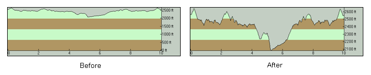 Notice how much more fine detail is noticeable in the "After" plot and how it does a better job of expressing which parts of the ride have a grade that is relatively uniform and which parts have more variation. At first blush, it might seem like placing the lower limit of the vertical axis always at zero would be a better way of standardizing these plots, since it sounds like it would make them more comparable to each other. When you think about it for a few more seconds, though, it will be clear that this is not the case. Since the vertical scale on the graph will be different for different rides (a ride taking place around 7000 feet would squeeze a 7000-foot range into the same graph height into which a ride not exceeding 500 feet would squeeze only a 500-foot range), no such direct comparability would exist. So, the best that one can do with a plot like this is to maximize the amount of the graph area being used to represent the detail of the plot by scaling the vertical axis to show only the range of elevations within the data being shown, just like how the horizontal axis is scaled to show only the range of distance in the data, which is now true for all elevation profile plots I show on this site. |
||
|
New ride: Crockett Hills March 29, 2015
It's not at all common for me to post a new ride on this site the very next day after doing the ride. It has happened maybe once or twice until now, and only when I felt that the content is urgent in its usefulness to all of us. Well, it has happened again today and it's for the same reason. Easily one of the most interesting things that have been going on in Bay Area mountain biking in recent weeks is the sudden, exponential growth in the popularity of Crockett Hills Regional Park. This month, I've received two unrelated messages from this site's viewers within the space of a single week, both suggesting that I post a Crocket Hills ride, which is unprecedented. There is a very good reason for this: the recent construction of three (yes, three!) flow trails built specifically for mountain biking. These additions, along with a couple of older singletrack trail segments in the park, make it possible to do a 13-mile ride here with nearly 80% singletrack mileage, like the one I've just posted. Let's tell all our friends, let's all enjoy these great new trails, and let's all behave responsibly and nicely while we do that and there will be much more of this to come. |
||
|
Updated: DeLaveaga Park March 23, 2015
I don't get to ride at DeLaveaga often, but I think I'll make a conscious effort to change that from now on. Most recently, I rode there last May. (This update has been waiting in the pipeline for quite a while.) I was surprised at how much better I found it to be than I remembered. It's easy to underestimate this park. I have to agree that it's not enough to be considered a true destination for people who'd be driving from long distances, but I think I'll be doing just that anyway, at least once a year. It shouldn't disappoint anyone looking for a short ride (or is okay with repeating trails) no matter what distance they've driven from. I'm sure it will surprise no one that I've used that last ride to refresh the material of the ride posted on this site. There's now a full photo set, where there were only three semi-relevant photos before. More importantly, the route shown is now more sensible and starts from the park's main parking lot, which is easier to get to and has many more spaces than the secondary parking option I was pointing out before. The description text is also much more fleshed out now and, hopefully, more informative. |
||
|
New ride: Mount Hamilton March 12, 2015
The new ride I'm adding to the site today is easily one of the most iconic road rides of our area. It wasn't overnight that I worked up the will power for this mountain climb and to convince myself that I'm in good enough shape to try it. In the end, however, I was pleasantly surprised. The climb on the ride is actually of a very manageable kind; it's just that there is a lot of it. You don't need race-winning cycling chops in order to make it to the peak. Those who can just keep pedaling all day at a slow burn can easily pull it off. The grade is possibly the most reasonable of any that you would find on a major mountain climb. The ride does rank among those with the highest total elevation gains on the site right now. So, it's nothing to sneeze at. But it's easily manageable by mere mortals who happen to be having a good season, and it's a very easy recommendation to make to all such riders. |
||
|
New ride: Hole-in-the-Ground Loop February 28, 2015
The Out-of-Area Rides section of the website receives a popular addition today. I don't think it would be an exaggeration to say that Hole-in-the-Ground Trail is one of the most popular ride options in the vicinity of Lake Tahoe for seasoned riders. In fact, this ride was recommended to me by a viewer via email. It was already on my radar at the time, but that suggestion pulled it closer to the top of my to-do list. If you look around, you'll find this ride being suggested for "strong intermediate" riders and above. I've found that this should be taken seriously. Beginners simply must stay away, and any intermediate riders who happen to be a bit out of shape for the moment should prepare themselves for a good amount struggling and a long day on the trail. For all others, though, there is a full serving of challenging mountain biking fun to be had on this trail by anyone's standards. Highly recommended for those who enjoy technical singletrack! |
||
|
New ride: Sierra Vista (Suggestion 2) February 15, 2015
Good things have been continuing to happen at Sierra Vista Open Space during the couple of years since Sierra Vista Trail was added to the very short roster of bike-legal singletrack trails east of Santa Clara Valley. These include Sierra Vista nicely aging into a little more seasoned hillside singletrack (rather than remaining a just-graded multi-use path), the creation of a nice little additional singletrack loop in the form of Aquila Loop Trail, and the opening of a new trailhead and parking lot on Sierra Road allowing much easier access to Sierra Vista Trail. Late last year, I did another ride at Sierra Vista to try out the different kind of Sierra Vista ride that these changes now allow; that is, different from the toughness of having to access Sierra Vista Trail from Alum Rock Park as reflected in the original Sierra Vista ride posted here. That new ride is now available as a second Sierra Vista ride suggestion. It should be a welcome addition for those riders who'd like to ride this nice and very scenic singletrack but can't stomach too many tough climbs. |
||
|
New ride: Demo Forest (Flow Trail) January 21, 2015
In addition to the scary news on the threat to bike access at Demo Forest about which I've posted here roughly a month ago, the other new thing at Demo is something a lot more positive: As many avid bikers in our area probably already know, limited sections of the Flow Trail being built there are now open to public use while construction still continues on the rest of the planned trail. Today, I've posted a new Demo Forest ride description that includes these currently open sections of this new trail. It's pretty exciting! The new trail will not feel alien to anyone who has tried Endor Trail in Camp Tamarancho. While I've tried it only once so far, it felt to me like it was a bit faster and a bit more aggressive than Endor Trail, if anything. I believe it's a pretty safe bet that this new trail will boost the popularity of Demo Forest with mountain bikers even further, especially as we get closer to its completion. On the flip side, this is bound to make the warning flag recently raised by CAL FIRE about irresponsible riding practices at Demo Forest that much more critical and the importance of heeding that warning that much higher. We all should bring this to the attention of everyone whom we know rides at Demo. Please spread the word! |
||
|
New ride: Mount Diablo (road climb) January 11, 2015
Here's one of the new, "longer" road rides I mentioned below that I've been doing this season. While not truly longer than the average road ride already listed on this site, the total climb of this route currently ranks as the second highest among the road rides represented here, so it's a "bigger" road ride than most that are available here. The amount of climbing on this ride is not a surprise, of course, given the fact that it tackles probably the most imposing mountain in our area. The ride is an easy recommendation to anyone who does road rides and can handle the amount of climbing involved. The excellent scenery that evolves as you make your way higher works as a wonderful distraction during the long climb as well as serving as a great reward for your effort. |
||
|
Updated: Harvey Bear Ranch January 6, 2015
The weekend before last, I rode at Harvey Bear Ranch. It was my first time riding there since I first added that ride to this site in 2011. The main thing that prompted this repeat visit was the recommendations to try Gaviota and Valley Oaks trails in comments left on the page by readers. I made sure to take a full set of photos on this repeat ride in order to expand the Harvey Bear ride route represented here. What I wasn't expecting is how much the ride impressed me. Valley Oak and Gaviota are beautiful trails indeed. But, even more than that, what came as a pleasant surprise to me was how Townsprings Trail and Calaveras Trail, both of which looked more like "half fire roads" at the time of my original Harvey Bear ride, have since transformed into very decent singletrack. This made me decide to post this update as soon as possible by pulling it ahead of a backlog of site updates that date from much earlier. So, the website now reflects Harvey Bear the way it deserves to be reflected. Perhaps most tellingly, while I originally had categorized the trail types of the Harvey Bear ride that I show here as consisting of 100% fire roads, my current assessment of this new ride places the singletrack percentage at an astounding 57%! This place truly qualifies as a local gem. |
||
|
New ride: Big Basin - Boulder Creek Loop December 23, 2014
The atypically high amount of rains we've been getting lately have prompted me to do more road rides than I usually do in the fall season (in addition to being a welcome break after last year's scary drought). I've also found myself trying out longer road rides this year than I had up to this point. The new ride I'm posting on the site today is one such example and is only one among a short backlog of similar new rides that I'm currently sitting on. This long loop through the deep, hilly backcountry of the Santa Cruz Mountains has sat on my to-do list for quite a while. For most of that time, it was waiting for me to find the right opportunity, but even more importantly, to muster the will power to attempt the ride. The fact that this ride now ranks as the entry with the largest amount of total climb on this site—and by a significant margin—should confirm that my initial intimidation was well warranted. It's an option that should satisfy riders who like a challenging romp through remote backroads. |
||
|
Bike access in Demo Forest at risk December 18, 2014
This came to my attention via an IMBA email yesterday. It looked so scary to me that I wanted to do my best to give it the widest audience possible. That's why I'm immediately announcing it here, which is my humble soapbox. MBoSC has posted an open letter from CAL FIRE (which manages Soquel Demonstration Forest) that raises the alarm that mountain biking in Demo Forest is at risk. The problem is unsanctioned trail building and riding, as well as night riding and unauthorized stunt building. Complaints from owners of adjacent private property and internal agency pressure is reportedly rising. The language being thrown around appears to include trail closures, ceasing of work on the flow trail, and denial of special event permits. Regardless of whether you take this to mean that biking in Demo Forest is imminently at exceptional risk or you interpret it as routine rhetoric to get people a little more in line, Demo Forest is one mountain biking destination of the Bay Area for which no level of access risk should be acceptable. The trail network at Demo is hands down the number-one favorite of advanced riders in the whole area. I can't even begin to imagine what it would be like to have bike access to Demo Forest trails banned or curtailed. So, the message I'd like to spread is this: if you see or know anyone who builds or rides unsanctioned trails or trail features at Demo Forest, please bring this to their attention. Spread the word, so that your fellow bikers may also do the same. This is a textbook case of why poaching or building unsanctioned trails is not really cool, clever, okay, justifiable, or—as some riders quixotically claim—"activism", and that, in the long run, it will only be counter-productive and end up hurting mountain biking access. If you'd like to see or join in the discussion on this issue, check out the related thread at MTBR.com, which is already pretty lengthy. |
||
|
New ride: Lower Rock Creek Trail December 4, 2014
I have an addition to my list of rides that are away from the Bay Area. In fact, this one is probably in the outermost reaches of the driving range I'm willing to undertake as part of a biking trip with an overnight stay. Its location on the other side of the Sierras and near the Nevada border may not exactly be convenient (especially when it's not serviced by any fast freeways), but Lower Rock Creek Trail is actually a nice gem. Its appeal might become clearer once you learn that this singletrack was built for mountain biking in the first place. Lower Rock Creek Trail is essentially an unbroken descent when followed in a southeasterly direction. This makes it a natural candidate for shuttle rides, which, I understand, is a popular way of riding it. I didn't have a way of arranging that for my own ride here, so I did it in the form of a round trip. While doing that, I did the climb back to the beginning via the Lower Rock Creek Road that parallels the trail closely, in order to save overall ride time because I had to drive back home to the Bay Area in the remaining part of the day. Just as it is whenever I write about a far away trail for a target audience centered around the Bay Area, one big question surrounding this ride is "is it worth the trip?" For someone who has an existing inclination to take day trips around California for the sake of bike rides, it's easily worth a try. However, if you've never done that before, this trail would not be my top recommendation for your first bike trip with an overnight stay. But, I was certainly not disappointed by one bit for having done the ride, despite a return drive that was stretched to more than six hours. |
||
|
Temporary workaround for geotagged photo maps November 29, 2014
Frequent users of the website may have noticed this already because I've made the change a few days ago, but the geotagged photo map feature of all the rides here, which links to EveryTrail.com, has now regained some functionality. Some features on EveryTrail have been returning to nearly normal levels of functionality since I last wrote about their troubles, however the full-page view of their ride map with photos is still not working. This full-page map is what the "View on a map" link of each of my rides used to point to. I've now given up hope that they'll ever fix that and, now that they are otherwise showing some signs of life again, I decided to change all of my geotagged map links to point to the home page of the EveryTrail version of the ride instead. This landing page has much more clutter than just the ride map and does not feature the thumbnail strip of all the ride's photos or their auto-starting slideshow, unfortunately. But, at least it works (most of the time). With some extra effort on the user's part, this page can still answer some questions as to what each part of a ride looks like and where a given picture has been taken. Until I can complete a more permanent solution, I'll have to make do with this approach. |
||
|
Updated: Ridgecrest Boulevard November 19, 2014
This ride represents the shortest route you can follow for sampling Ridgecrest Boulevard, providing the easiest way to check out this local treasure as long as you're okay with a significant and relatively long climb. It was, therefore, a serious weakness that the content for this ride had a number of shortcomings until now: it was missing a full photo set, it was traversing Ridgecrest in the less fun direction (uphill), and it had minimal text in its description. I've now fleshed it out and fixed all of these, in addition to changing the starting point to Stinson Beach, thereby allowing much better options for some post-ride treats as soon as you complete the ride. I only wish I could provide photos from springtime in order to show the beauty of this road at its most jaw-dropping, but that will have to wait for a later update. |
||
|
Fat Tire Flyer November 13, 2014
This probably won't be news to some of you, but I want the rest of you to hear it too: There's an excellent new book out there by Charlie Kelly titled Fat Tire Flyer. Taking its title from the newsletter that Charlie had started in those early days (which happens to be the first mountain biking publication in the world), the book seems to tell the full story of the birth of mountain biking with a level of completeness and detail that I haven't seen anywhere else so far. It also includes plenty of other small treasures for any mountain biking history buff such as plenty of rare photos, drawings, the results and best times of all Repack Races, and an appendix full of supplementary accounts and interviews. In case you don't know Charlie Kelly, he's been in the epicenter of the origin of mountain biking from day one in addition to being the organizer of historic biking events like the Repack Race and the Appetite Seminar, the co-founder with Gary Fisher and Tom Ritchey of the first company that built mountain bikes, and the de facto historian of the birth of the sport. By the way, I'm not affiliated with the book or its publisher in any way, or make any direct gain from its sales. I'm not personally acquainted with Charlie Kelly either. It's just that resources as good as this about the "distant" past of mountain biking do not come along often (or at all, until now), so I'd like to help as much as I can in getting the word out for the benefit of all who might be interested in the topic. |
||
|
New ride: Repack Road (via Camp Tamarancho) November 3, 2014
Repack Road may not be the most interesting or the most fun trail even within its immediate vicinity, but no one can deny the fascination it holds for anyone even remotely interested in the history of mountain biking due to the central position it holds in the origin story of the sport. While Repack was represented on this site since day one, the only ride route I used to show here that included Repack Road was optimized more for minimum effort than for maximum fun. I've now added what should be the preferred route for intermediate to advanced riders who are interested in trying out Repack Road. This variation uses less road mileage on the way up and includes an excellent stretch through the technical singletrack of Camp Tamarancho instead, while also incurring more elevation gain and slightly more overall mileage in the process. I think this version qualifies as more of a "must-try" ride for any riders beyond beginner level. Meanwhile, the original Repack ride route I represented on the website is still on the list, with the exception of having its title revised (so that its core purpose of traversing Repack Road is clearer, as it is with this new version) and having some of its text and map links a bit more fleshed out. |
||
|
Updated: Mount Diablo (Oyster Point Trail) October 19, 2014
The GPS track available for this ride used to be a "doctored" one until recently, because my ride on which it was based is actually a loop on which I had had to traverse an illegitimate route due to some bad planning and I had been forced to manipulate the GPS data of that ride in order to produce a track representing how I should have done the ride (as an out-and-back route). Since then, I have repeated the ride in the out-and-back form that I recommend. I have now replaced the GPS track of the ride with the one from this newer ride. This does not make much practical difference. It only makes the data as genuine as the other tracks on this site and it allows me to remove from the ride description a paragraph in which I used to apologize for providing manipulated GPS data. However, I also took a new set of photos when I repeated the ride. Since the original photos of the ride were from the season when everything is straw colored and the beginning part of the original ride had been in some fog, this new set shot when the hills were green and the views were clear constitutes a big improvement in how things look. I have, therefore, replaced the old photo set with these newer images as well. |
||
|
Updated: Joaquin Miller October 5, 2014
The content for the Joaquin Miller ride on this site had originally been posted in 2010. Since then, a number of things changed in the trail network of this park; some significant, some less so. Coupled with a few details about the original ride route that left room for improvement, I felt that these changes meant that the information of the Joaquin Miller ride was due for an overhaul. That overhaul is now done. I hope this bumps up the usefulness and relevance of my coverage of this East Bay treasure. For those who are curious, here are the things that changed:
|
||
|
New ride: Annadel (Suggestion 3) September 28, 2014
Considering how large and great the trail network of Annadel State Park is, the two Annadel ride suggestions I had listed on this site until now had little hope of doing it justice. I now have a third ride option here that should fill in this gap a little bit, though it still leaves a good amount of Annadel riding goodness to be covered in the future. This new ride route includes several singletrack segments on which I had a blast, as well as a couple that I've discovered would be much better in the opposite direction. A case can probably be made that you'd have little hope of putting together an Annadel ride route that traverses all included trail segments in the ideal direction anyway (at least for longer rides). This new ride should ideally be taken as a set of directions to ride those trails that it takes in the "correct" direction and as source material to put together a different ride route to try out the remaining ones in the opposite direction. |
||
|
Mountain biking job September 25, 2014
Are you serious enough about mountain biking to be interested in making some money out of it? This Craigslist posting was brought to my attention by a viewer of this site. It's about a head coach position for a high school mountain biking team in Marin, though the posting is already a month old. I'm not sure how common such opportunities normally are, but I don't see anything wrong with posting this one here. Pass it along to anyone whom you think might be interested. |
||
|
Updated: Wilder Ranch (Eucalyptus Loop and Long Meadow Trail) September 20, 2014
I'm pleased to flesh out a ride option at one of my favorite ride locales that has been listed on this site since its first launch. The Eucalyptus Loop and Long Meadow Trail route at Wilder Ranch is not my favorite one in this park, but it should rank closer to the top of the lists of greener riders. While avoiding some of the potentially intimidating stretches of trail in the park, it still combines a sampling of nice singletrack with other thrills like blasting down the miles-long descent in the last part of the ride with the partial accompaniment of ocean views. This particular ride was missing a decent photo set since the beginning and did not represent the singletrack re-routing of part of Engelsmans Loop on the way up. Both of those shortcomings are remedied by this update. |
||
|
New ride: Iron Horse Trail September 7, 2014
I was hoping that I could manage to avoid a slowdown in the updates to the website during my summer travel season this year, but a combination of obligations piled up on top of a couple of travel plans once again and resulted in this six-week dry spell in my stream of ride updates. No worries. Here's the first of a number of updates to the site that have been waiting in the pipeline for a few months. Having no other weekend-eating plans in my immediate future, I think I should be able to resume a higher pace in the addition of new content to the site in the coming weeks. This one is a casual ride. Due to its impressive (and growing) length, Iron Horse Regional Trail had been on my radar since the beginning. I haven't acted too quickly in finding an opportunity to try out this trail, but better late than never. It would make little sense for people to drive here from other places in order to ride on Iron Horse (like I did for the sake of representing it on this site), but this trail is a good resource for those living within easy access of it. |
||
|
Geotagged photo maps not working August 10, 2014
I've mentioned this in my preceding posting on this page as well, but this now appears to deserve its own entry: The geotagged photo maps linked from my ride descriptions aren't working. It seems to be official that EveryTrail has crapped out on me and, not only is it no longer possible for me to post new geotagged photo maps there, but even viewing the existing ones isn't possible anymore. I'd just like any concerned viewers of the site to know that I am acutely aware of the situation and that I have started looking into finding a replacement solution as quickly as I can. In other words, the geotagged photo maps will definitely be back, though it might not happen too quickly, since I'll be pursuing a home-grown solution this time, as this experience has clearly demonstrated the risk of relying on third parties for features like this (at least when that third party isn't Google, I suppose). |
||
|
New ride: Salmon Falls (Darrington Trail) July 28, 2014
The next new out-of-area ride for the website is a leftover that has been waiting on my backlog since this spring. Salmon Falls is not going to be news to any riders from the Sacramento area or to anyone who has done any amount of biking in that vicinity. It's for good reason! I've found this ride to be more satisfying than both Forest Hill Divide and New Melones, which are the two other rides that are, respectively, the closest one and the most similar one to Salmon Falls represented in the out-of-area rides list on this site at the moment. It also doesn't hurt that it's one of the options closest to the Bay Area that are currently listed in that section. I might not be willing to drive from San Francisco to do this ride repeatedly but, knowing what I now know about the ride, I do find it easily worth one try. Some viewers of the site may notice that this ride is not accompanied by a geotagged photo map. The EveryTrail website, which I use for geotagged maps, has become flaky lately and their functionality for uploading a new ride has not been working in the last few days. I figured I'd post the ride without a geotagged map rather than delaying the addition of the ride until they fix things. Unfortunately, this is only the latest piece of evidence for the noticeable decline of EveryTrail over the last year or so. All indications point to a need for me to come up with an alternate solution for geotagged maps as soon as possible. Until I can pull that off, the geotagged photo map functionality of the website may have to remain a bit patchy and inconsistent for a while. I apologize for that in advance. |
||
|
Updated: Round Valley July 21, 2014
Round Valley does not rank very highly at all on the popularity list of the rides listed here. Still, if it deserves to be on the site at all, I think it deserves to have content that matches the standard of all the rest of the rides on the site. With that thought in mind, I took the opportunity to repeat the Round Valley ride this past spring in order to add some photos to it (which it was lacking completely). This also allowed me to discover that it's now possible to do the portion of the ride in the valley as a loop, which wasn't true before. Although doing the ride in a loop reduces the total mileage and elevation gain, I changed the route to do it that way. (After all, a viewer who's interested in this easy meander on mostly flat fire roads might even prefer a shorter and easier ride anyway.) I also discovered that Hardy Canyon Trail is now legal for bikes. I haven't included it on the ride route in this update, but may tweak the ride route again later on in order to use that trail as the return route (for variety). (Update: A viewer has since let me know that this news about Hardy Canyon Trail is not true and that this has been verified by a park official. The new map must be marked incorrectly.) |
||
|
Updated: Skeggs Point (Suggestion 3) July 13, 2014
It's not that often that a top-tier ride locale in our area acquires a brand-new, bike-legal singletrack, but that is exactly what has just happened at Skeggs Point. Having learned about it thanks to a viewer comment left on the "Suggestion 2" ride for Skeggs Point on this site about a week ago, I have done a ride at Skeggs just yesterday to try out the new Oljon Trail. It turns out that that user comment may have been left on the very day this new trail was opened to the public, because a ranger I encountered during my ride yesterday said that the trail had opened only "last week". While starting out at its top as an uninteresting fire road, most of this new trail is actually singletrack and it descends with plenty of switchbacks to meet Steam Donkey somewhere between the two tough climbing spells that you'd encounter when doing that latter trail in its entirety in the downhill direction. I've now updated the "Suggestion 3" ride to follow this new trail instead of riding on Skyline Boulevard to get to the very beginning of Steam Donkey. I think this qualifies as an improvement to this ride because it avoids the risk (and monotony) of riding in traffic even for that short distance, as well as making the ride slightly shorter and reducing its total elevation gain a little bit; not to mention the fact that the new Oljon Trail is more fun than those initial stretches of Steam Donkey anyway. Incidentally, I've also kept the original version of this ride for those who might like to get their hands on a GPS track of the entire length of Steam Donkey or to see its photos. It's now linked from the main ride page as an alternate version of this ride. |
||
|
New ride: Uvas Reservoir July 4, 2014
The next new road ride for the site is from the (far) South Bay. Your experience on this ride could range from idyllic (if you try it in early spring) to oven-like (if you make the mistake of trying it in the height of summer). Quite an expanse of fairly untouched lands lie just a few minutes of driving distance west of Highway 101 in this area and this ride explores a small slice of these. The fact that most of the ride is not flanked by thick tree cover (so that the views are pretty open) and that it passes by two sizeable reservoir lakes are bonus points for the ride. I think this ride carries more than just local appeal. Though I wouldn't claim that it's worthwhile for everyone to come and try it, I do think that it deserves the drive down for cyclists living in the South Bay. |
||
|
Updated: Pacifica June 25, 2014
The Pacifica ride listed here was not exactly out of date or lacking in content. Still, I decided to expand the ride route to include an out-and-back extension into Gray Whale Cove Trail that, until now, was only being explained in the text as a possibility. I think this is a worthwhile addition and means the ride route more completely represents the majority of legal trail options available from this starting point. The photo set is also replaced with a completely new one now, in addition to the changes to all of the stats, naturally. One possibly odd side effect of this change is that more than half of the ride route now appears to take place on what I've classified as a "paved trail". (The paved percentage used to appear only as 35% before this change.) This is because a good chunk of that extension onto Gray Whale Cove Trail takes place on more of the crumbling pavement of Old San Pedro Mountain Road. The ride title that used to be "Pacifica to North Peak" is also changed to simply "Pacifica" now. I think that's fair since the route no longer consists of a straight climb right to that peak. |
||
|
Updated: Mount Tam (Old Railroad and Eldridge Grades) May 16, 2014
One of my "old favorite" rides represented on the site has had fairly slim content since day one. I don't find this loop nearly as challenging as I used to during my novice days, but it's just as scenic as it has ever been; and the rocky descent on Eldridge Grade might not involve any of the adrenaline for me that it used to back in those days, but I find it even more fun now, if anything. This ride now gets the full set of pretty photos that it deserves, updated maps, and a few additional paragraphs in its description text. |
||
|
New ride: Nicasio Reservoir Loop May 8, 2014
I wouldn't feel I've made good use of spring unless I can put in at least one road ride in the pleasant countryside of northern Marin County during this green season. One such ride I did this spring was a new one for me, so I took the opportunity to add it to the website. This one is not materially different from similar rides already on the site such as the Marshall - Chileno Valley Loop and the Cheese Factory Loop, but I think it still sits in its own little niche in being the shortest and easiest ride in this vicinity that's represented here. On top of that, it provides an excellent excuse to spend some time in Point Reyes Station; which I always appreciate, ride or no ride. |
||
|
Updated: Henry Coe (Grizzly Gulch) April 30, 2014
I don't get to ride at Henry Coe as frequently as I would like to. Part of that is due to its remoteness and part of it is my aversion to its peak tick season. Still, I was lucky enough late last year to put in two Coe rides in fairly quick succession. The first of those had already made it onto this site as the new Middle Ridge Loop option. The second one was a repeat of the Grizzly Gulch loop and it took me this long to come around to updating the site with the fresh content from that repeat ride. This ride now gets the usual full photo set treatment as well as more detailed text and tweaked stats and ratings. |
||
|
New ride: Brushy Peak April 10, 2014
Brushy Peak was not on my radar until a viewer suggested it to me. There aren't many trails here and almost all the trails are of the least interesting kind of East Bay fire roads. The unexpected perk that I've come to discover at Brushy Peak is hidden behind that word "almost" though: There is actually singletrack available here, and parts of this are pretty fun and technical singletrack. The selection is small, but it's there. This is not enough to make this place anything more than a handy option for a workout ride for the locals of the area, but the place still qualifies for representation on this site in the interest of "full coverage", in my opinion. |
||
|
New ride: New Melones (Glory Hole) March 29, 2014
This is a ride that I had heard a lot about and what I had heard are all good things. The trails here are almost all singletrack. While it's not the kind of technical singletrack that would satisfy any craving for gnar, I was still pleasantly surprised by how entertaining these trails are. And the scenery can hardly be better. This being a ride along the shores of a large reservoir lake, I knew it wasn't going to be ideal to try the ride in the kind of an extraordinary year of drought that we're having right now, but I didn't want to postpone my sampling of this location to next spring. So, the current photos of the ride won't reflect the scenery of the ride at its best, unfortunately. I can't claim it's worth driving all the way from the Bay Area just to be able to try this ride. But, if you will be in that area for any other reason anyway and have a chance to try out a local ride, this option will not disappoint. |
||
|